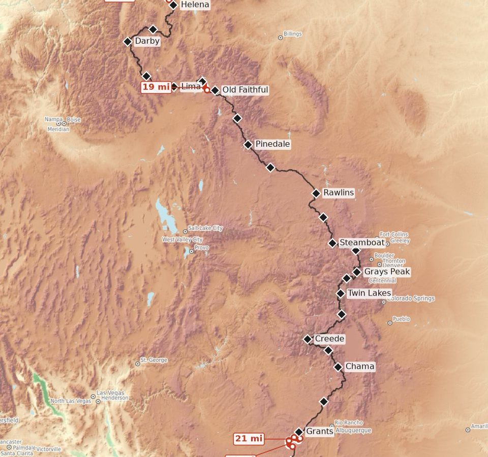
The most valuable spreadsheet I made for the Hayduke Trail was the one that allowed me to calculate one thing: how far is it to the next water I can count on? This told me the water carries I could expect, how miserable my pack volume might be, and where I should consider caching or looking to resupply.
I think when it comes to desert hiking, that’s a pretty common question, and something that can eat up a lot of planning time. As such, I pulled the water data from the CDT, PCT, and AZT to help answer the same question. I highlight all the points on these trails where there are long stretches (15+ miles on the PCT or 18+ miles on the CDT and AZT between reliable water sources.)
Because there’s a bunch of caches that are well-maintained by trail angels (thank you all so much!), the water carries through the desert sections of these trails are pretty manageable. Additionally, ranchers in these communities are pretty good at maintaining tanks and windmills, and they are reliable enough to plan on using them. Because of water caches and other human-maintained water sources, you’re unlikely to have any water carries over 30 miles in a typical year.
The maps I built out below highlight every stretch of trail that is 18 miles or more (15 on the PCT) between reliable water sources. I also include information about the handful of sources that, if they are turned off or not reliable for one year, could turn a normal water carry into a real slog.
Summary Table
| Trail | Season | Long carries | Longest Likely Carry |
| PCT | NOBO | 4 | 17.3 mi (Swarthout Canyon Road cache → Guffy Spring) |
| PCT | SOBO | 13 | 23.3 mi (Stream Below Trail → Concrete Cistern) |
| CDT | NOBO | 4 | 22.4 mi (Lordsburg → Juniper Spring Tank) |
| CDT | SOBO | 9 | 27.0 mi (Lordsburg → Solar Well) |
| AZT | NOBO and SOBO | 1 | 18.3 mi (Wildlife Tank → Russell Tank & Gate) |
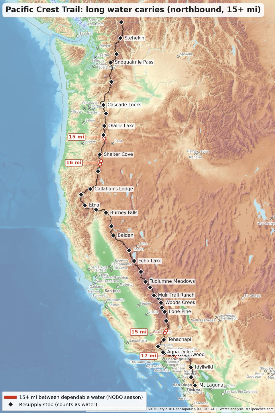
Once the water caches at road and trailhead crossings are counted, the PCT has 4 stretches of 15 miles or more between reliable water northbound, and the longest is about 17 miles. Southbound is a different story: 13 stretches, the longest about 23 miles, mostly in Southern California where the creeks and springs have dried up by the time southbound hikers get there in October and November.
For the CDT, of course it’s New Mexico (there are also a couple of long carries in Montana). Northbound, none are likely to be over 23 miles, and southbound the longest is 27 miles.
The AZT has one “long” carry at a modest 18 miles.
What I consider a dependable water source
I generated some statistics for each well-documented water source on each of these trails. For each water source, I calculate a probability that that source is dry on the dates that the typical hiker reaches it. These data are populated from past trail conditions and hiker comments. I use the typical northbound (and separately southbound) calendar from my bubble tracker, and average the chance of the source being dry over a three week period on either side of the median date a hiker reaches that water source.
A source is dependable if the chance it is dry, given the math crunched above, is 15% or less. Most New Mexico tanks, windmills, and solar wells are likely to have water in them during the typical hiker season, which makes up the key water sources hikers plan to use. Named rivers are also quite reliable. Sources that have a lot of variability or uncertainty in any given year don’t end up getting counted as reliable, so are removed from consideration for planning purposes on this site. Well-maintained water caches are also viewed as reliable (including the ones hikers report on at road crossings and trailheads, as long as the typical report around that date is at least a few gallons on hand), as are towns and resupply stops. I also consider any water source that is reliable and within 2 miles off trail. A carry is the distance between consecutive dependable points along the route, and I consider anything that is “18 miles or more” to be a long water carry, and the rest to fall within the typical 1.5 to 2 liters of water folks are typically carrying by default.
I will note that because I am modeling reliable sources, this page does not reflect current conditions. The only way to know for sure, is to have up-to-date, real-time data about that source. Comments on the FarOut guide, for the year that you’re hiking, is the best place to find the most up-to-date data for these three trails.
A dry year or an early start can very quickly impact the sources that are considered to be reliable. Make sure to check current water reports before every long carry, and especially before the sources in the “check first” lists below.
Pacific Crest Trail water carries
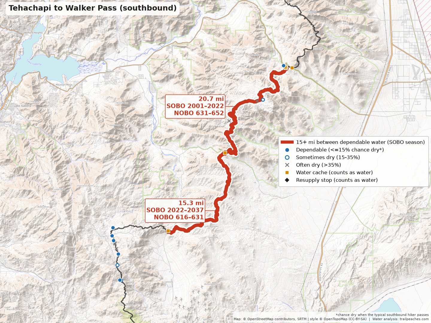
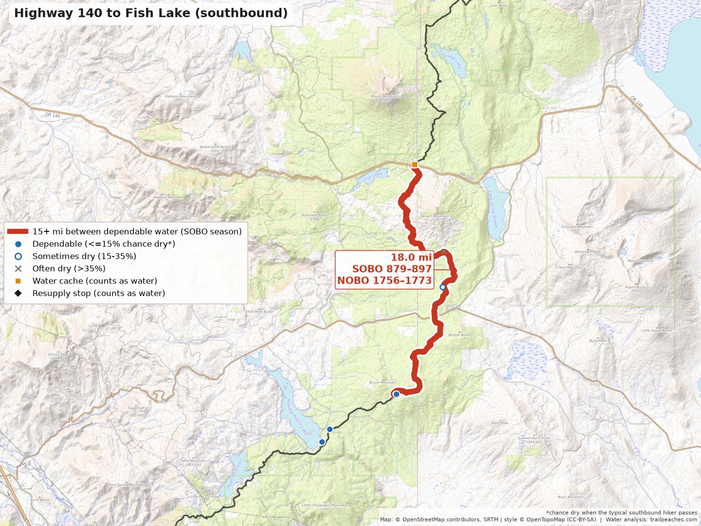
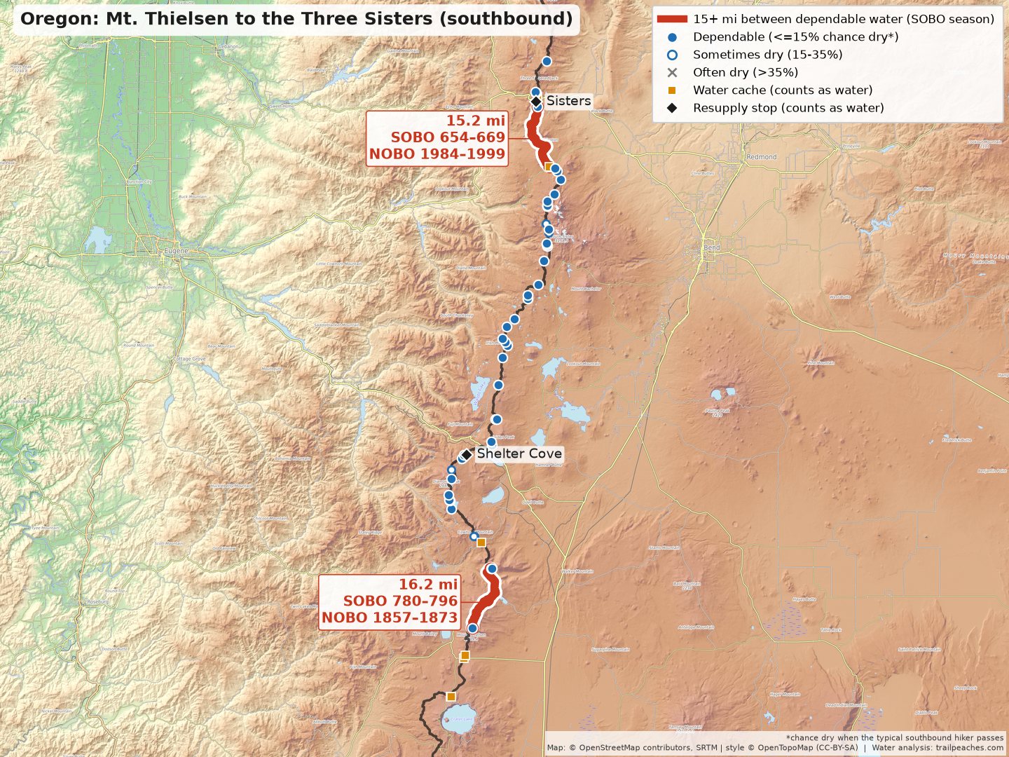
There are 4 carries of 15+ miles northbound and nothing over 18 miles. I used a lower cutoff for the PCT since there are so few long ones once the caches are counted. The caches at Scissors Crossing, Kelso Road and Bird Spring Pass, and a lot of other road crossings, keep the low desert from turning into a long carry. Because Cache 22 (he’s a good friend) maintains his water cache out of Hat Creek Rim, this is no longer an especially long, dry stretch of trail. The LA aqueduct has faucets that are reliable. Southbound is much drier. There are 13 carries of 15+ miles, most of them in Southern California, because the seasonal creeks and springs there are mostly dry by the time southbound hikers arrive in October and November, and there is less information on the caches for those dates.
For the PCT I fit a model to the full history of past comments, with a year effect and a seasonal curve for each source, and weighted each source by when northbound (or southbound) hikers actually get there. That is how late-season dryness shows up in the southbound numbers.
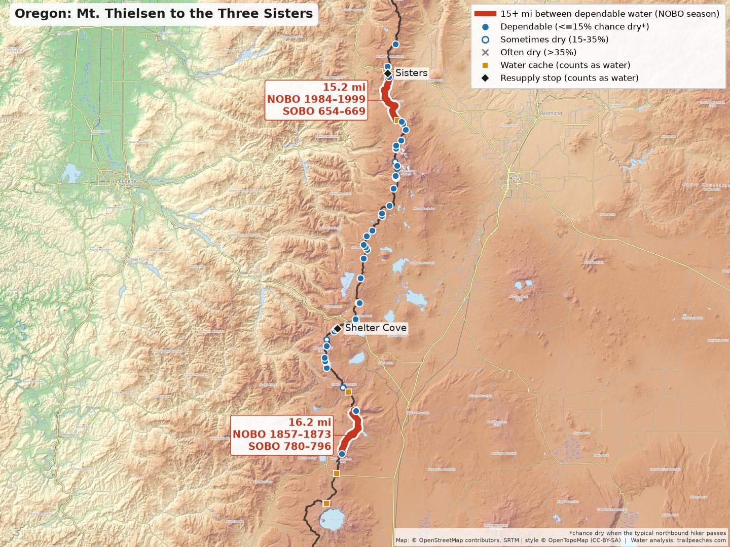
Northbound season
| Trail miles | Last dependable water → next | Carry | In between (best bet → longest leg if it has water) |
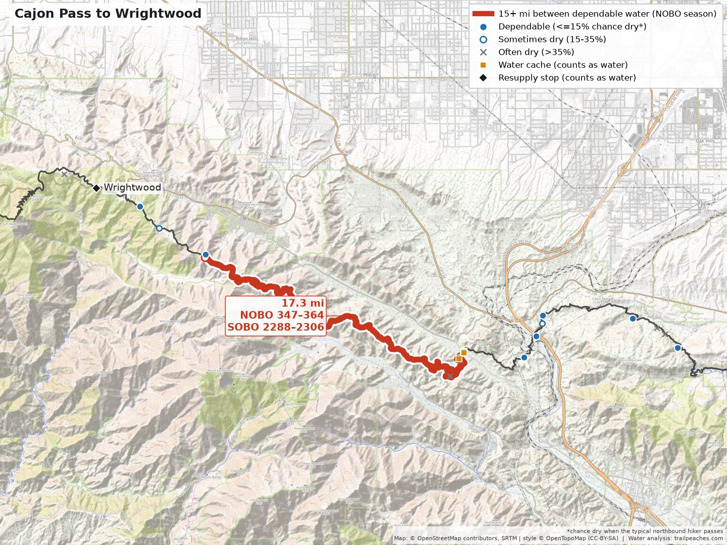
| NOBO 347–364 SOBO 2288–2306 | Swarthout Canyon Road cache → Guffy Spring | 17.3 mi | best bet: Dry Stream Bed (mi 348, ~78% dry) → longest leg 16 mi |
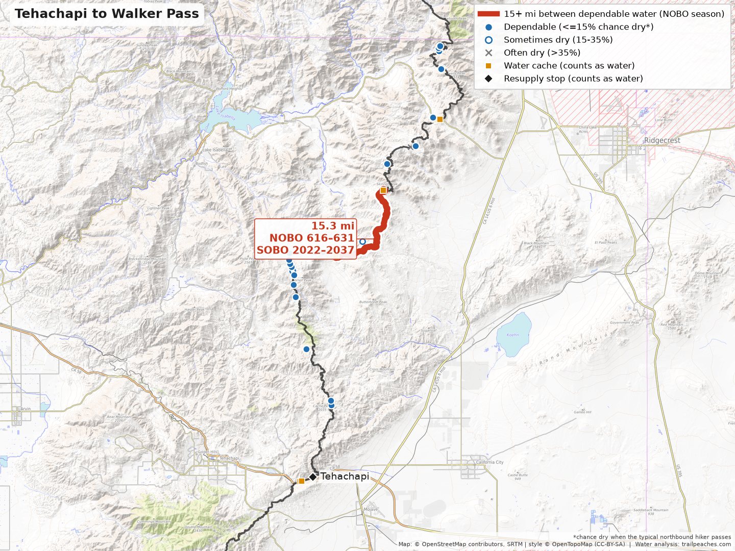
| NOBO 616–631 SOBO 2022–2037 | Kelso Road → Bird Spring Pass | 15.3 mi | best bet: Willow Spring (mi 620, ~21% dry) → longest leg 10 mi |
| NOBO 1857–1873 SOBO 780–796 | Thielsen Creek → Six Horse Spring Junction | 16.2 mi | nothing mapped |
| NOBO 1984–1999 SOBO 654–669 | PCT McKenzie Pass Trailhead → Small Pond | 15.2 mi | nothing mapped |
Southbound season
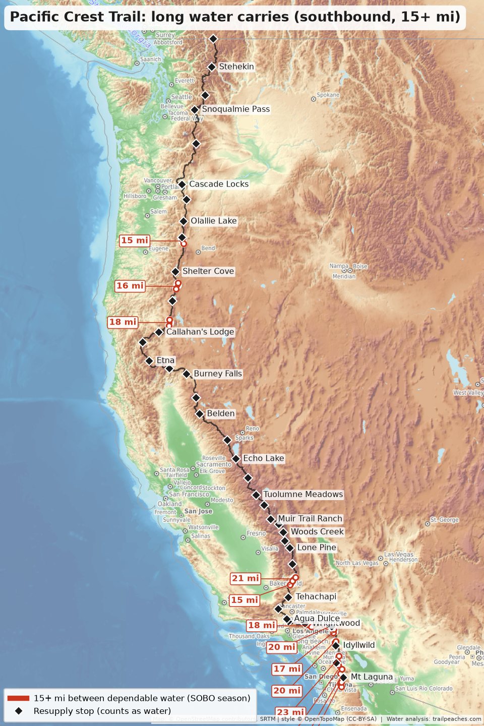
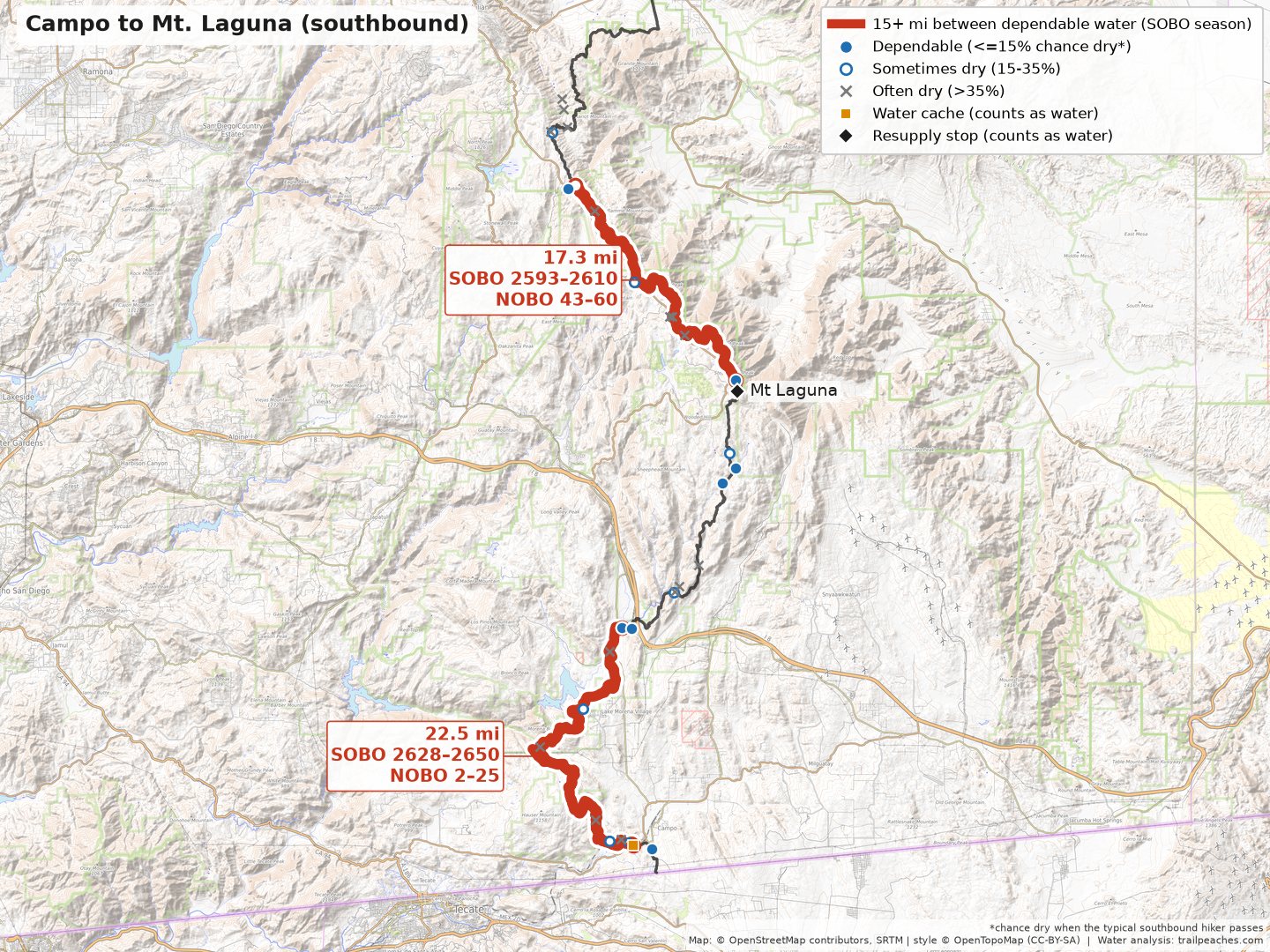
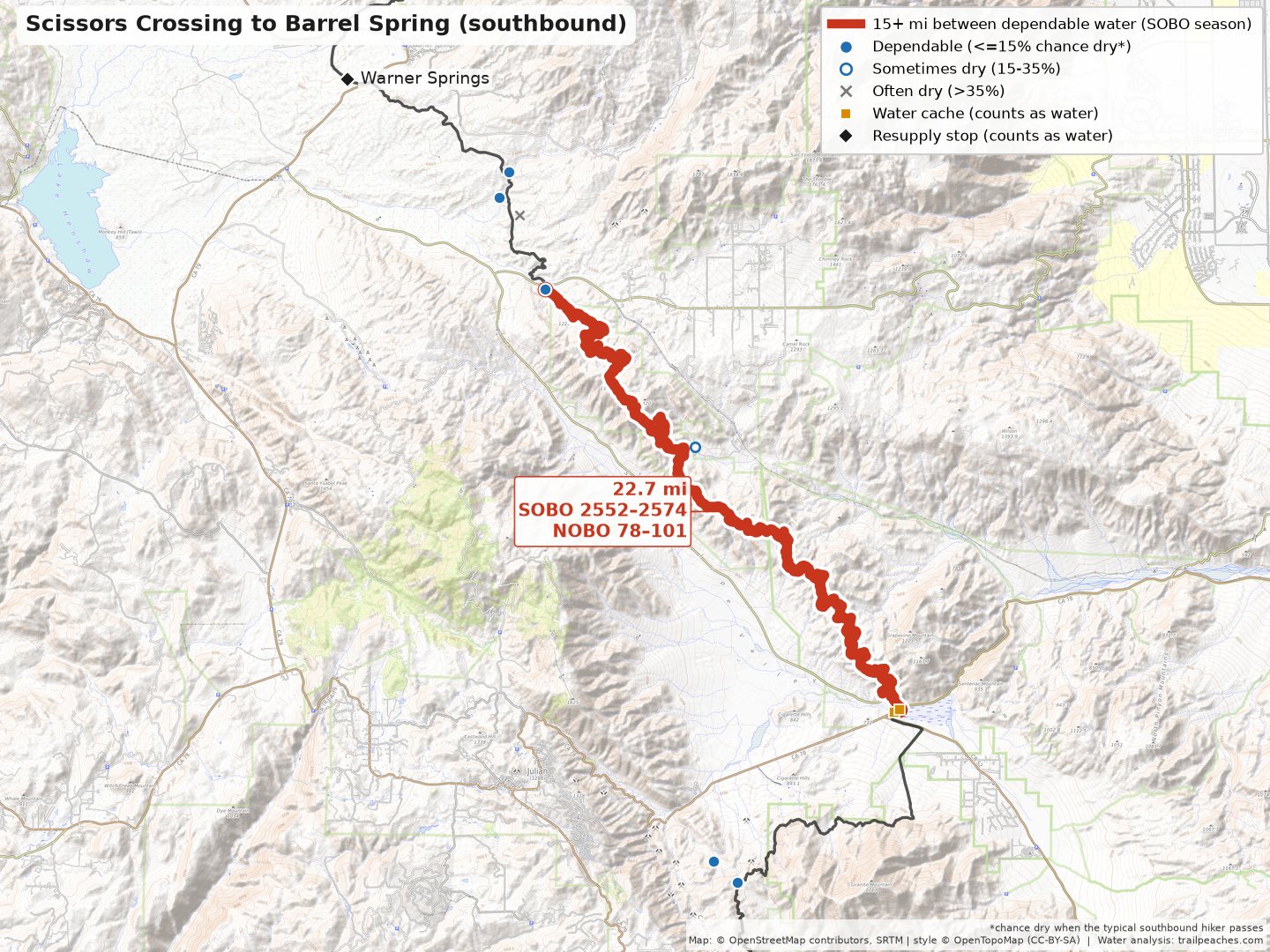
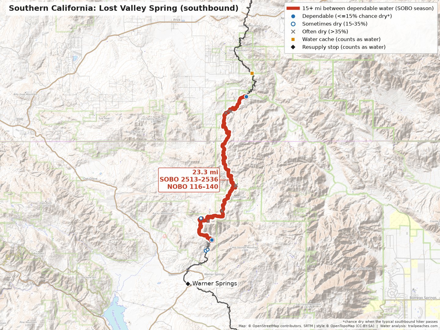
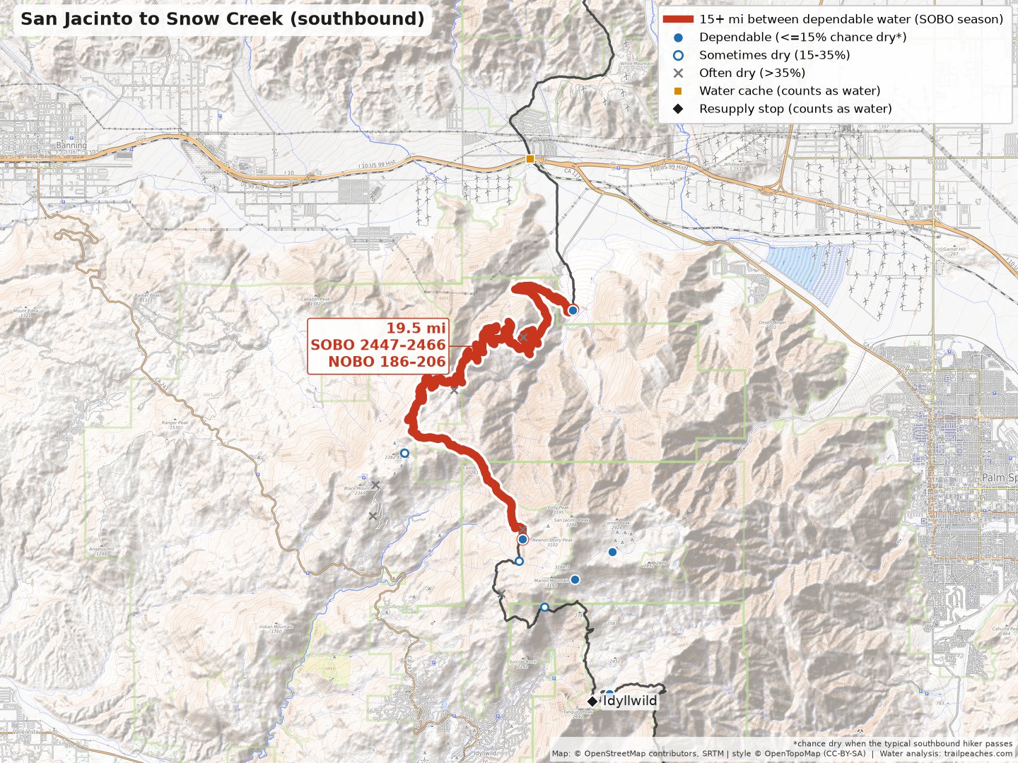
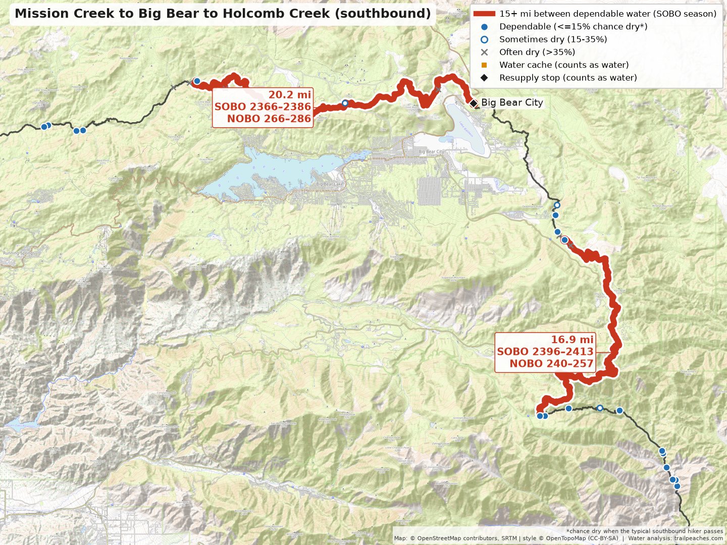
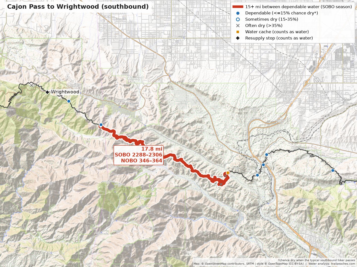
| Trail miles | Last dependable water → next | Carry | In between (best bet → longest leg if it has water) |
| SOBO 654–669 NOBO 1984–1999 | Small Pond → PCT McKenzie Pass Trailhead | 15.2 mi | nothing mapped |
| SOBO 780–796 NOBO 1857–1873 | Six Horse Spring Junction → Thielsen Creek | 16.2 mi | nothing mapped |
| SOBO 879–897 NOBO 1756–1773 | Highway 140, Access to Fish Lake Resort → Spur to Piped Spring | 18.0 mi | best bet: South Brown Mtn Shelter (mi 889, ~17% dry) → longest leg 10 mi |
| SOBO 2001–2022 NOBO 631–652 | Junction to Walker Pass Campground → Bird Spring Pass | 20.7 mi | best bet: Cabin & McIver’s Spring (mi 2008, ~23% dry) → longest leg 13 mi |
| SOBO 2022–2037 NOBO 616–631 | Bird Spring Pass → Kelso Road | 15.3 mi | best bet: Willow Spring (mi 2032, ~32% dry) → longest leg 10 mi |
| SOBO 2288–2306 NOBO 346–364 | Guffy Spring → Swarthout Canyon Road cache | 17.8 mi | best bet: Seasonal Bike Spring (mi 2306, ~88% dry) → longest leg 17 mi |
| SOBO 2366–2386 NOBO 266–286 | Little Bear Springs Camp → Big Bear City | 20.2 mi | best bet: Caribou Ck & Tentsite (5) (mi 2377, ~21% dry) → longest leg 11 mi |
| SOBO 2396–2413 NOBO 240–257 | Spring → Mission Camp Water Trough | 16.9 mi | best bet: Arrastre Trail Camp (mi 2396, ~49% dry) → longest leg 16 mi |
| SOBO 2447–2466 NOBO 186–206 | Water Faucet → N. Fork San Jacinto River | 19.5 mi | best bet: Seasonal Stream (mi 2462, ~33% dry) → longest leg 15 mi |
| SOBO 2513–2536 NOBO 116–140 | Concrete Cistern → Stream Below Trail | 23.3 mi | best bet: Lost Valley Spring (mi 2533, ~16% dry) → longest leg 20 mi |
| SOBO 2552–2574 NOBO 78–101 | Spring & Tentsites (5) → Scissors Crossing | 22.7 mi | best bet: Underground Cistern (mi 2561, ~23% dry) → longest leg 14 mi |
| SOBO 2593–2610 NOBO 43–60 | Sunrise Trailhead (0.3 mi off trail) → Desert View Picnic Site | 17.3 mi | best bet: Pioneer Mail Picnic Area (mi 2600, ~23% dry) → longest leg 10 mi |
| SOBO 2628–2650 NOBO 2–25 | Cottonwood Creek → Cross Highway 94 | 22.5 mi | best bet: Stream & Tentsite (5) (mi 2650, ~17% dry) → longest leg 22 mi |
More on the PCT: my Pacific Crest Trail guide.
Continental Divide Trail water carries
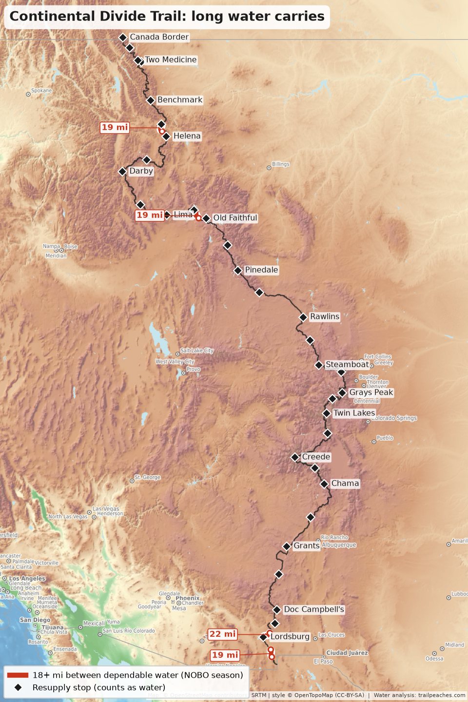
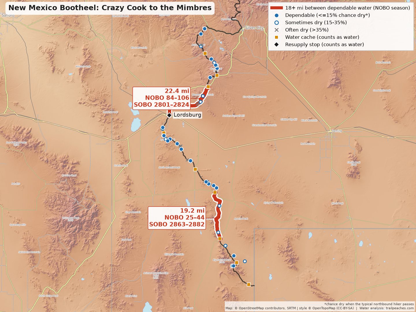
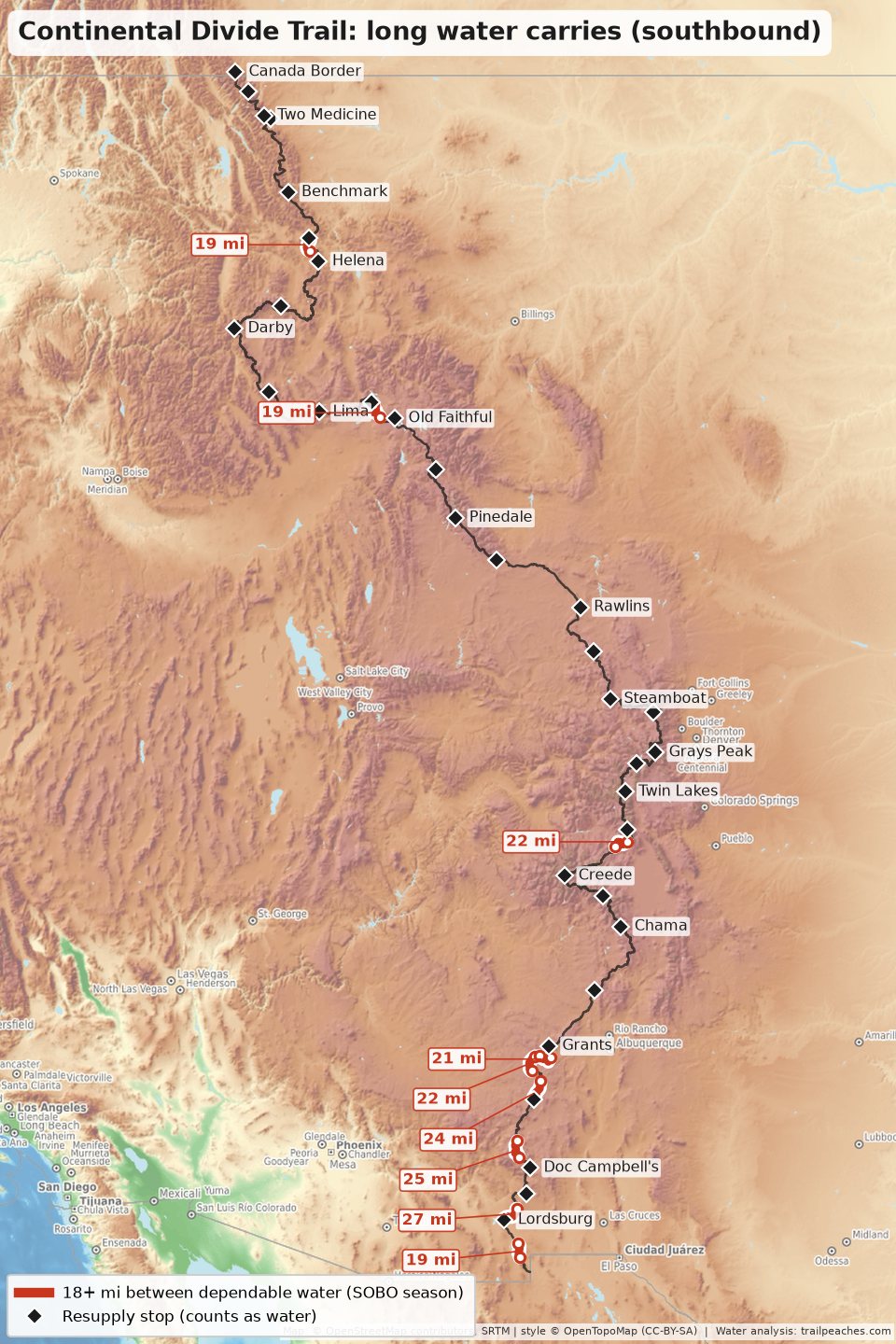
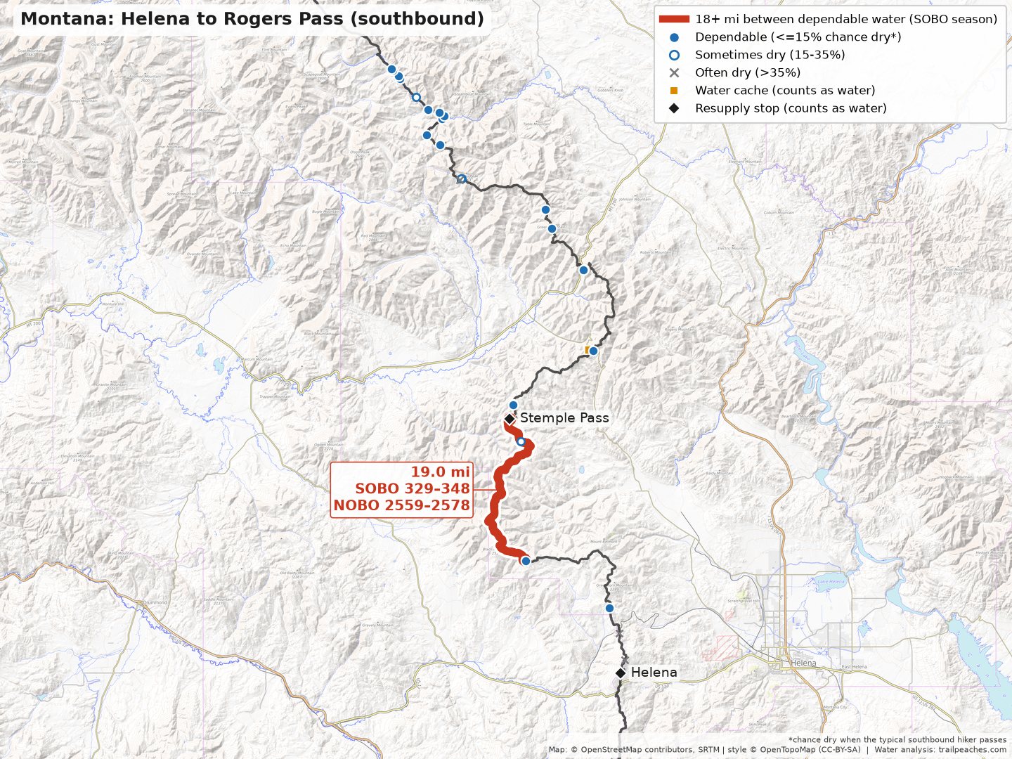
There are 4 carries of 18+ miles when heading northbound during the typical season. The longest carry is 22 miles (Lordsburg to Juniper Spring Tank). The Bootheel cache boxes, the solar wells, and the road crossing caches through New Mexico make the carries quite manageable! Southbound there are 9, and the longest is 27 miles (Lordsburg to the first solar well), because the road crossing caches are reported as less stocked at typical southbound dates.
Route note: Because the CDT is 1 part “choose-your-own-adventure”, the miles I use follow my CDT courses, which takes the official route through New Mexico, except I went through the Gila.
Northbound season
| Trail miles | Last dependable water → next | Carry | In between (best bet → longest leg if it has water) |
| NOBO 25–44 SOBO 2863–2882 | Water Cache Box → Water Cache Box | 19.2 mi | best bet: Water Tank (mi 38, ~14% dry, but swings a lot year to year) → longest leg 13 mi |
| NOBO 84–106 SOBO 2801–2824 | Lordsburg → Juniper Spring Tank | 22.4 mi | best bet: Engineers Windmill (mi 99, ~29% dry) → longest leg 15 mi |
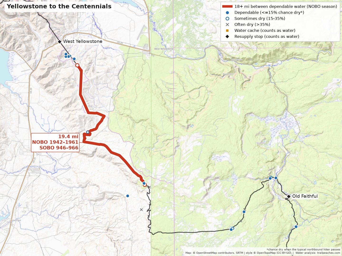
| NOBO 1942–1961 SOBO 946–966 | Small Pond → Seasonal Pond (0.7 mi off trail) | 19.4 mi | best bet: Reas Pass Creek (mi 1951, ~16% dry) → longest leg 10 mi |
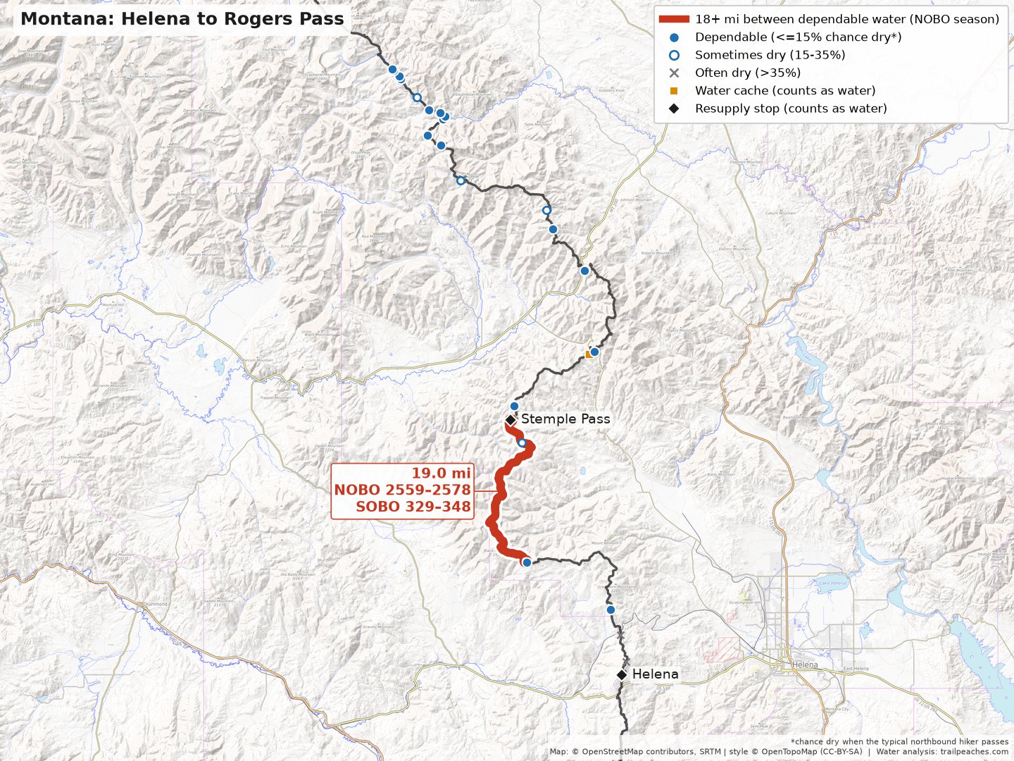
| NOBO 2559–2578 SOBO 329–348 | Dana Spring → Stemple Pass | 19.0 mi | best bet: Spring 1/2 mile NE (mi 2576, ~25% dry) → longest leg 16 mi |
Southbound season
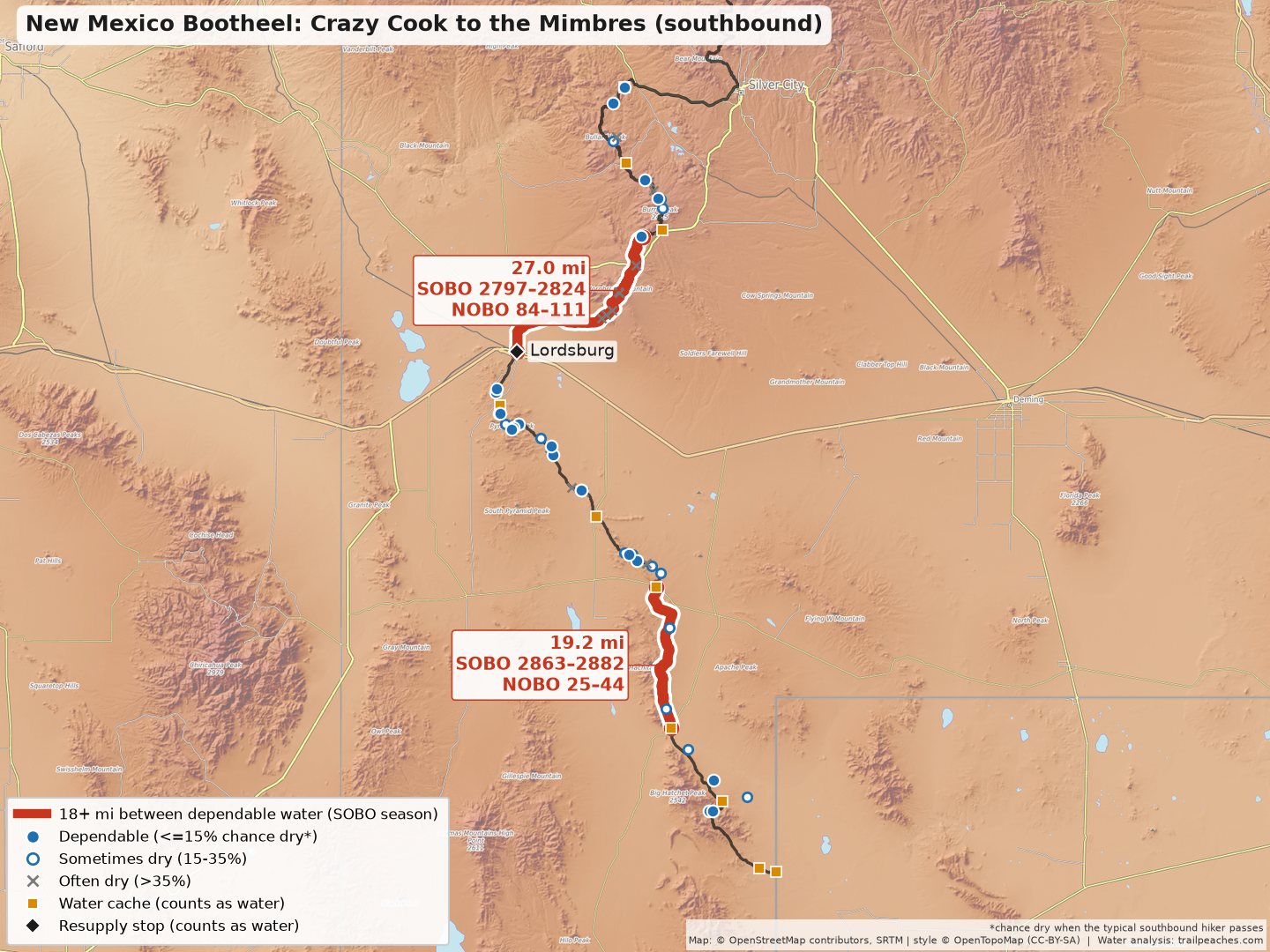
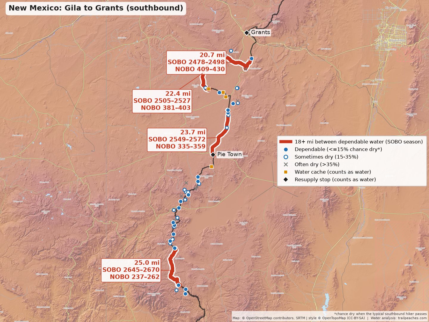
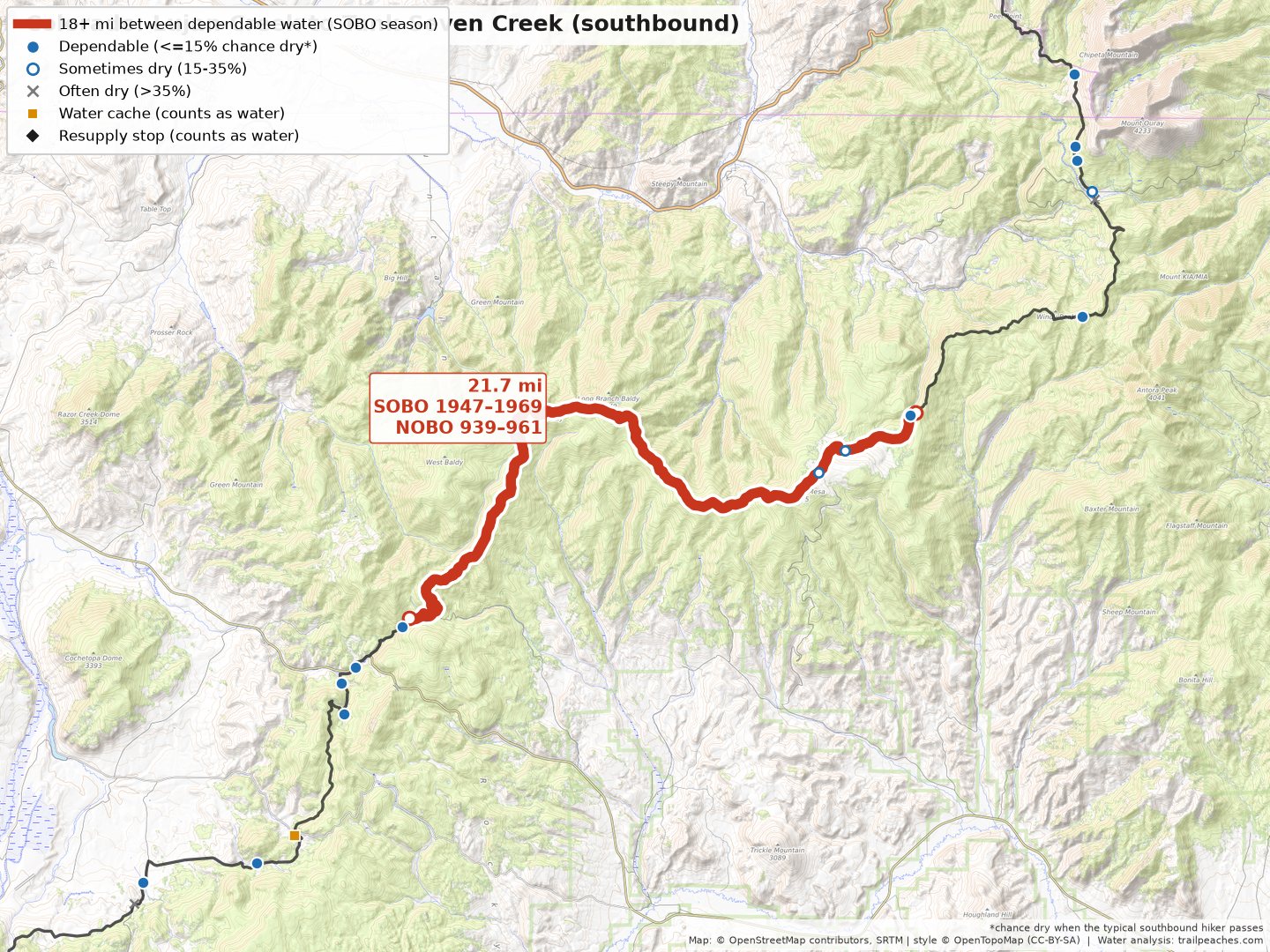
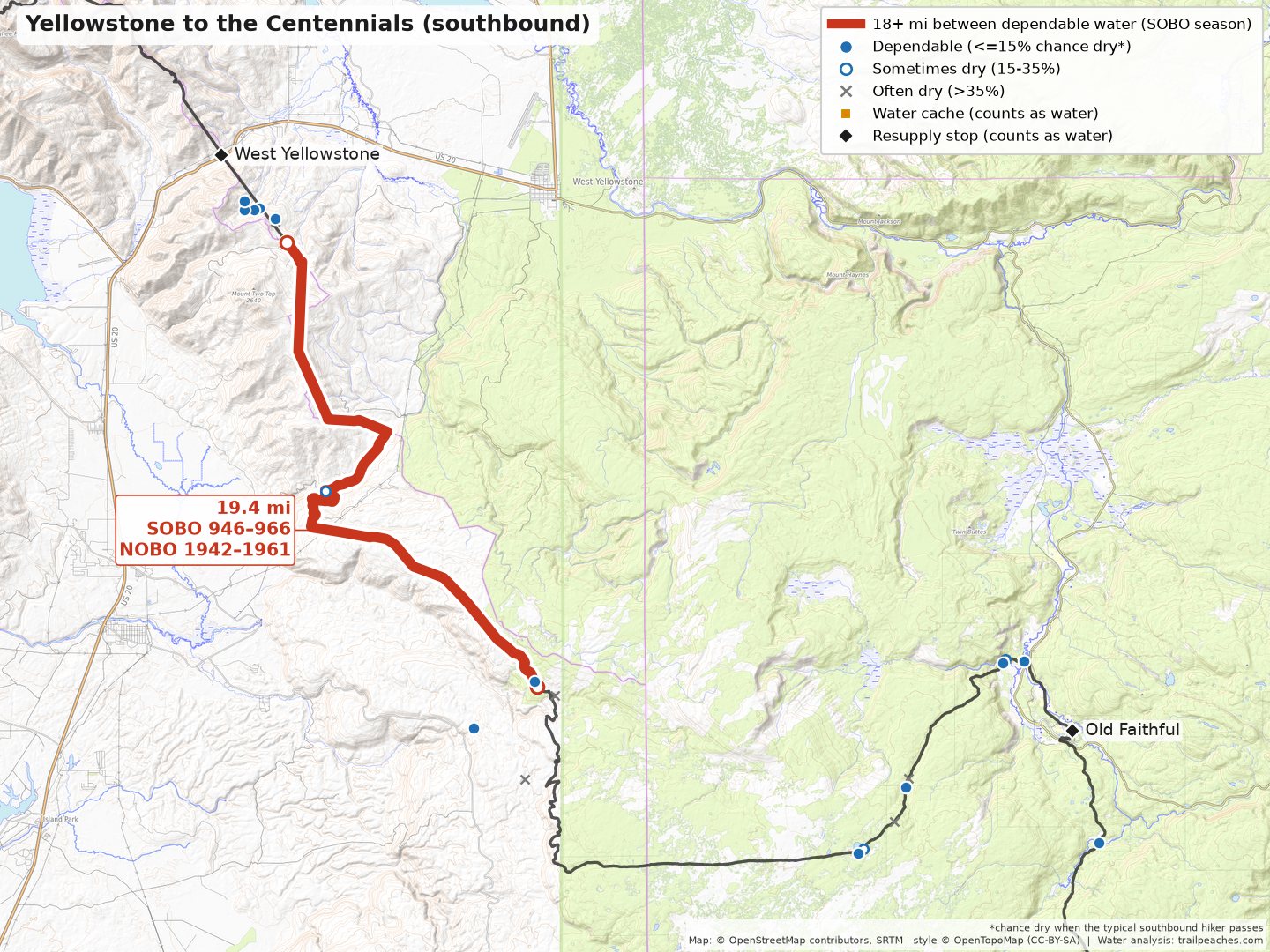
| Trail miles | Last dependable water → next | Carry | In between (best bet → longest leg if it has water) |
| NOBO 25–44 SOBO 2863–2882 | Water Cache Box → Water Cache Box | 19.2 mi | best bet: Water Tank (mi 38, ~15% dry, but swings a lot year to year) → longest leg 13 mi |
| NOBO 84–111 SOBO 2797–2824 | Lordsburg → Solar Well | 27.0 mi | best bet: Engineers Windmill (mi 99, ~37% dry) → longest leg 15 mi |
| NOBO 237–262 SOBO 2645–2670 | Gila River (HIGH ROUTE) → Solar Well | 25.0 mi | best bet: Clear Creek & Junction (HIGH ROUTE) (mi 238, ~4% dry) → longest leg 25 mi |
| NOBO 335–359 SOBO 2549–2572 | Pie Town → Solar Well (0.6 mi off trail) | 23.7 mi | best bet: Solar tire tub (mi 358, ~25% dry) → longest leg 23 mi |
| NOBO 381–403 SOBO 2505–2527 | Trail Post → Water Tank/Cache | 22.4 mi | best bet: Junction to Water Tank (mi 383, ~19% dry, but swings a lot year to year) → longest leg 20 mi |
| NOBO 409–430 SOBO 2478–2498 | El Malpais Information Center → El Malpais Ranger Station | 20.7 mi | best bet: Hwy. 117 & Cebolla Alternate (mi 424, ~60% dry) → longest leg 15 mi |
| NOBO 939–961 SOBO 1947–1969 | Lujan Creek → Tank Seven Creek | 21.7 mi | best bet: Seasonal Stream (mi 947, ~16% dry) → longest leg 14 mi |
| NOBO 1942–1961 SOBO 946–966 | Small Pond → Seasonal Pond (0.7 mi off trail) | 19.4 mi | best bet: Reas Pass Creek (mi 1951, ~18% dry) → longest leg 10 mi |
| NOBO 2559–2578 SOBO 329–348 | Dana Spring → Stemple Pass | 19.0 mi | best bet: Spring 1/2 mile NE (mi 2576, ~23% dry) → longest leg 16 mi |
Check a report first
These are the sources that really prevent a long carry from being necessary. If one of these sources is dry, then you’ll end up with water carries that are over 30 miles. Oof.
| Trail miles | Source | Chance dry | Carry if it is dry | Matters for |
| NOBO 111 SOBO 2797 | Solar Well | ~4% | 30 mi (Lordsburg → Water Cache) | SOBO |
| NOBO 237 SOBO 2670 | Gila River (HIGH ROUTE) | ~25% | 31 mi (Gila River → Solar Well) | SOBO |
| NOBO 2559 SOBO 348 | Dana Spring | ~14% | 34 mi (Road-Trail Junction → Stemple Pass) | NOBO/SOBO |
More on the CDT: my Continental Divide Trail guide, the CDT water explorer, and the offline water app.
Arizona Trail water carries
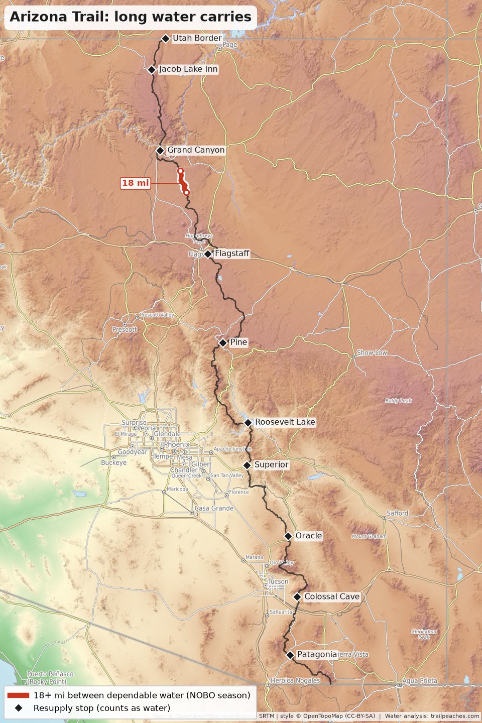
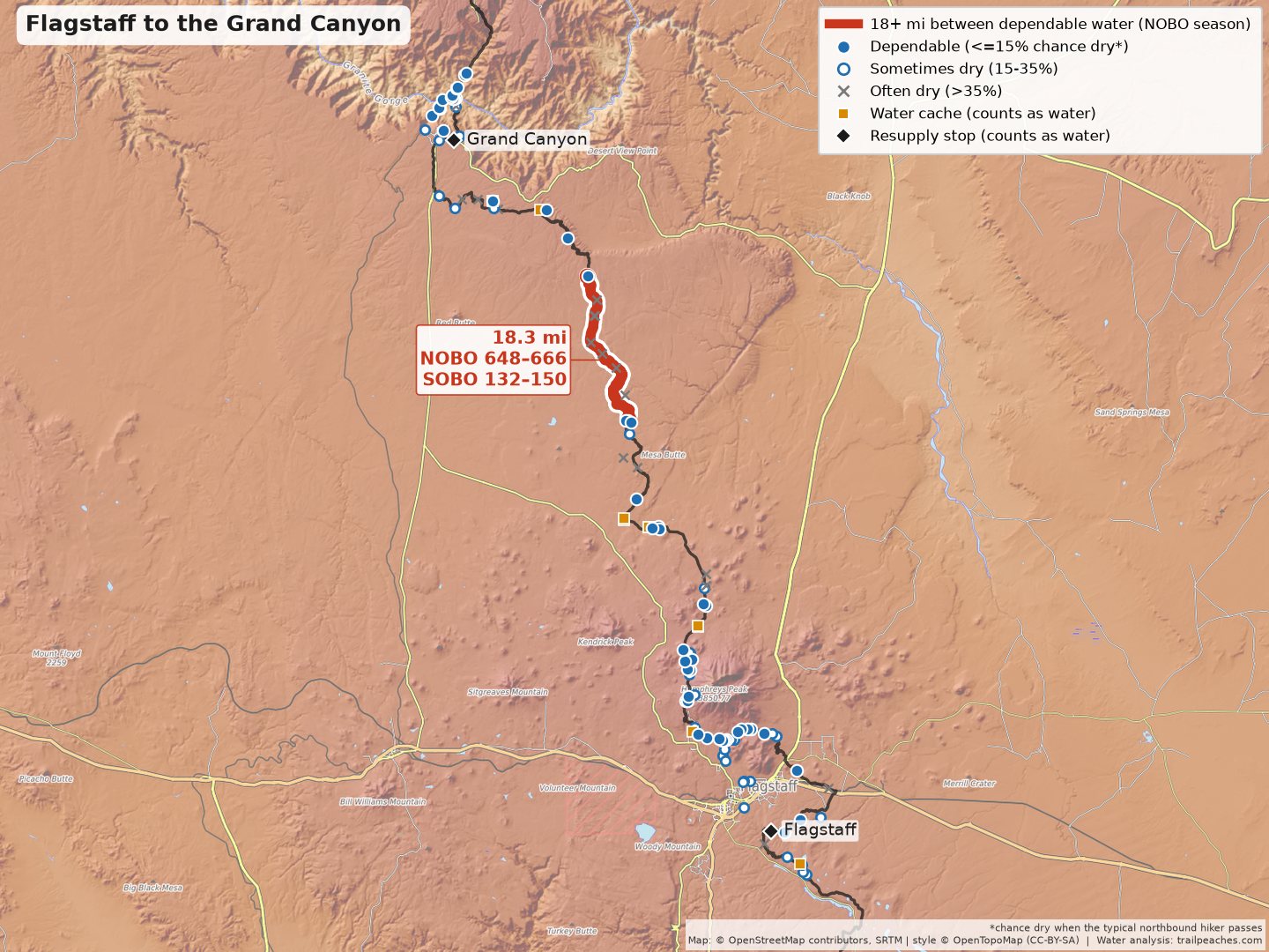
There is only one carry over 18 miles on the AZT. This appears to hold up for either hiking season. The dry stretch is on the Babbitt Ranch north of Flagstaff. Other than that, the AZT has plenty of water! Sure, it might be from muddy cow troughs and tanks, but it’s there!
Northbound and Southbound season
| Trail miles | Last dependable water → next | Carry | In between (best bet → longest leg if it has water) |
| NOBO 648–666 SOBO 132–150 | Wildlife Tank (0.4 mi off trail) → Russell Tank & Gate | 18.3 mi | best bet: Rollover Gate & Junction then TH (mi 666, ~23% dry) → longest leg 18 mi |
Check a report first
These are the sources that really prevent a long carry from being necessary. If one of these sources is dry, then you’ll end up with water carries that are over 30 miles.
| Trail miles | Source | Chance dry | Carry if it is dry | Matters for |
| NOBO 648 SOBO 150 | Wildlife Tank | ~7% | 34 mi (Cedar Ranch Trailhead → Russell Tank & Gate) | SOBO |
More on the AZT: my Arizona Trail guide, and the AZT water explorer.
Are there any issues with these data?
Oh, hell yes. I modeled this based only on the well-known, mapped sources and the affiliated hiker comments over time. I used a variety of parsing techniques to turn hiker comments into quantifiable data, which of course can introduce some errors, but for the most part is pretty accurate. I tuned the model to be conservative.
I’ve also counted the documented water caches as reliable sources because they are typically well-maintained by the trail angel community. With that said, a huge wave of hikers can rapidly empty a cache. Additionally, the trail angels supporting a cache could disappear for a season (or more). For caches at road crossings I only count them when the comments from around the typical date describe several gallons on hand, and those comments mostly cover the last couple of seasons.
Crazy changes in precipitation or weather can greatly impact water reliability. If a source has a probability of being dry only 10% of the time, that can greatly mask the water reliability for something that is fine nine years out of ten and dry in the tenth. If a source seemed to have high variability in terms of whether or not it had water, I did not include it as a reliable water source for assessing the water carries.
Side trails: a source up to 2 miles off trail that is reliable I counted as an option when considering what constituted a long water carry. The Whitewater Preserve, for example, is half a mile off the PCT.