Hiking the Arizona Trail
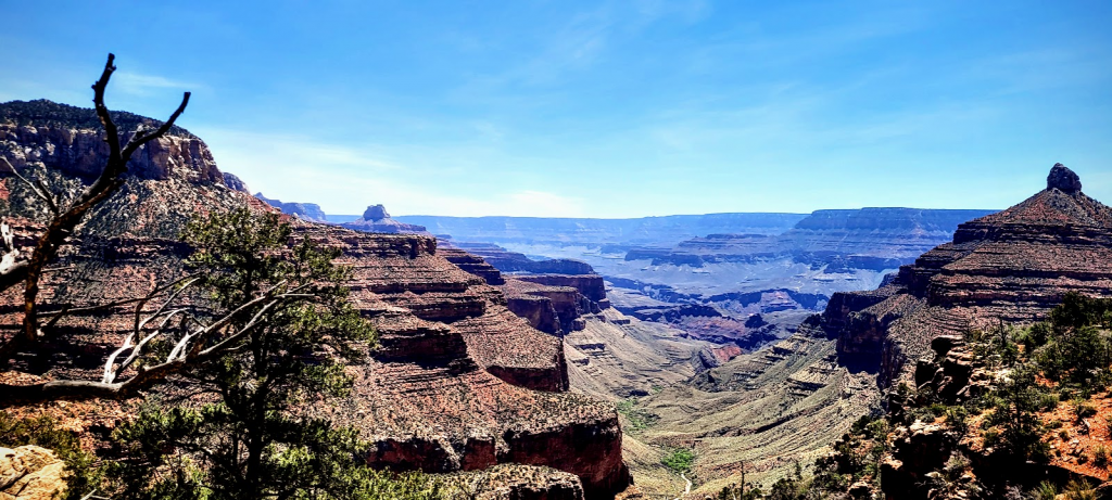
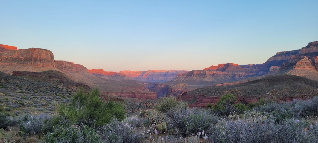
Mile for mile, the Arizona Trail might be the prettiest long trail in the country. It runs 800 miles from the Mexican border to the Utah border at the Grand Canyon’s North Rim, through desert, sky islands, ponderosa forests, the Grand Canyon, and the Colorado Plateau. I thru-hiked it in March-April 2023 in 32 days.
The AZT is dramatically underrated. Most people know that the Grand Canyon is world-class terrain, but fewer realize how spectacular the trail is in its other sections. I strongly recommend this trail to anyone who can do it.
Arizona Trail thru-hike: what you should know before starting
Season and Timing
The AZT is a spring and fall trail. The desert sections in southern Arizona are too hot to hike in summer, and the mountain sections in the north can be snow-covered in winter.
Best northbound start: Late February to mid-March. Starting here gives you the best weather in the southern desert and lets you arrive at the Grand Canyon in late March or April when conditions are good. I started March 26, 2023 and had excellent conditions.
In 2023, the Grand Canyon section was partially closed due to exceptional snowfall that triggered rockslides on the North Kaibab trail. To get around this, I pulled together a semi-technical alternate through the inner canyon. Snow year variability in the northern sections is something to monitor before your start date.
How Long Does It Take?
Most thru-hikers finish in 30-45 days. I finished in 32 days, which required consistent 25 and 30 mile days. The trail is more crisy than something like the CDT or PNT, and the spring desert conditions make for fast hiking in the mornings!
Arizona Trail permits
There’s really no permit concerns. The only thing that you need to be on the lookout for is the Grand Canyon permit if camping below the rim. There are limited permits for pantom ranch that are very popular — apply early at recreation.gov or call the backcountry office at (928) 638-7875. Apply 4-6 months in advance for a spring thru-hike.
There is also a permit required for crossing the Navajo Nation (for some approaches or alts into or out of the canyon).
Navigation and Apps
FarOut (formerly Guthook) has an AZT guide, which pretty much everyone buys. Water sources in the desert are critical planning information, and other hikers will update the FarOut app with current water conditions that can help you plan. I’ve also generated a probabilstic distribution below for water quality and information, and placed the waypoints most likely to have water on a GPX file and Garmin course. Download navigation maps and courses before heading out on trail.
The Grand Canyon Section
In 2023, a 7-mile stretch of the official AZT was closed through the Grand Canyon because extreme snow had triggered rockslides on the North Kaibab trail. Most other thru-hikers ended their trip at the South Rim. Instead, I led a group of three other hikers on a 3-day, 15-mile semi-technical alternate through the inner canyon that let us cross from the South Rim to the North Rim with a continuous footpath.
This alternate required routefinding through unmaintained terrain and some technical scrambling. It’s not something I’d recommend for most hikers.
Planning and Resupply
The AZT is reasonably straightforward for resupplies without sending too many packages. My complete travel itinerary with resupply notes is linked here. I have a bunch of course files for navigating with a Garmin GPX below. I sent a package to Collosal Cave, Roosevelt Lake, and some Challenger shoes to Pine.
| Resupply Option | Mile | Notes |
| Coronado National Monument / Southern Terminus | 0 | Start at the Coronado National Memorial border monument. Get a shuttle out of Tucson. AZT association maintains a shuttle list. |
| Patagonia | 51 | Small town with a small grocery store. Trail access from mile 44 with about 11 miles of road walking round-trip into town. Perffectly solid resupply. |
| Colossal Cave Mountain Park | 126 | Mail drop. The park accepts packages. On-trail access. Closes at 6pm. They have ice cream and a smaller shop. Plan your arrival timing well. (16721 E Old Spanish Trail, Vail AZ 85641) |
| Oracle | 211 | Small town with a grocery store and hardware store. On-trail alternate gets you into Oracle without a hitch. There’s also Biosphere 2 nearby! Which is a trip! |
| Superior | 306 | Former mining town with a full grocery store! It’s pretty trail-friendly with a great trail angel! Good stop before the Roosevelt Lake stretch. You can overnight here with the trail angel. |
| Roosevelt Lake Marina | 350 | Mail drop. Marina store has limited supplies. It’s likely worth sending a package to avoid the hitch into Globe (15+ miles). (28085 N. Hwy 188, Roosevelt AZ 85545) |
| Pine | 462 | Solid trail town, basically on trail. Grocery store in is about 2 extra miles of walking to get there. “That Brewery” is slightly closer and accepts resupply packages. |
| Flagstaff | 570 | Full service city. There’s an REI. severa; Big grocery options, and tons of great restaurants. Just take the official AZT “flagstaff alternate route”. You can ship microspikes here if they’re needed for the north rim. |
| Grand Canyon South Rim (Maswik Lodge) | 700 | On-trail. Maswik Lodge store can be a little pricey, but is quite exceptional with everything you might need! If you plan to camp at Phantom Ranch, you’ll need your Grand Canyon backcountry permit by this point. Apply months in advance if you tend to camp in the bottom. Otherwise you can do it as a day hike down and up. You can also do some offtrail stuff and can get permits the day before, typically. |
| Jacob Lake Inn | 772 | On-trail (2 miles of highway walking). Small store and lodge with a restaurant often out of things. Last resupply before the Utah terminus. Typically enough stuff to get you a coulple days on trail if you’re not picky. A lot of folks send packages (if you stay the night it’s included, otherwise they usually charge about $25 for a package). |
| Northern Terminus | 799 | Utah state line north of the North Rim. It’s pretty remote, so you’ll want to arrange a shuttle to Page or Kanab in advance. You can also hitch, but it may take a while. |
Why I Navigate With a Garmin Watch
A Garmin Fenix is the best navigation upgrade I’ve made to my backpacking kit. It does four things my phone can’t.
- It sips power. The battery is tiny, so a typical power bank tops it up 15-20 times. In my experience it runs about 4 whole days of solid navigation between charges.
- Built-in flashlight. The Fenix 7X (and some other Fenix models) has an LED flashlight. It’s one of the features I use most on trail.
- More time in nature. The course lives on my wrist, so my phone stays in my pocket.
- Off-course alerts. It pings you when you drift roughly 150 feet off the course. It has saved me MANY miles of unnecessary backtracking.
Garmin Fenix 7X Solar Sapphire on Amazon Read my Garmin watch review
Affiliate link: if you buy through it I may earn a small commission at no extra cost to you.
Garmin Courses: AZT Resupply Splits
10 Garmin courses (799 miles), one per resupply stretch. Download the ZIP, import the TCX files into Garmin Connect, and send them to your watch. They include water points along the way.
Each file is one stretch between resupply stops from my plan, with the start and end loaded as named course points. I split them up because Garmin Connect and the Garmin watches often crash with long courses or a lot of waypoints. Follows the official passages and matches official AZT miles. The urban Flagstaff alternate (Passage 33) isn’t included. The Flagstaff stop is the point on the main route nearest town, so expect a hitch or a few extra miles of road.
TCX files include water waypoints, which I optimized to reduce water carrying concerns
Every TCX course file has water course points built in, picked to keep carries short and the odds of finding water high.
- Reading the names: each name starts with the route mile, then the source, like
101 Twin Tanks. A~in front (~244 Stock Tank) means decent odds, 60 to 85%. A?means it’s the best option in a thin stretch and may be dry. No symbol means 85% or better odds of having water, which is about 9 in 10 of them. Names get cut at 15 characters. - What the odds mean: the chance the source isn’t dry for a northbound hiker leaving the border around March 25, using the worst case within three weeks of when you’d arrive. A pool or stock tank counts as water, so check the note on each point for its chance of flowing, and plan to filter tank water.
- Gates and junctions: a few points are listed as a gate or junction. Hikers report water there or nearby, and the note on the point says so.
Heads up: I hiked the AZT before I owned a Garmin watch, so I never ran these on trail. They’re built from my resupply plan, not from a course I carried. The tracks come from third-party sources, so accuracy isn’t guaranteed. Carry backup navigation, and check the course against your own maps. If a long course won’t import, split it smaller with the Trail GPX Converter. The converter’s AZT preset now loads with these same water points.
↓ Download all 10 courses (ZIP)
Or grab individual courses (10)
Water Data and Analysis for the AZT
I built a model to better visualize and assess water availability on the AZT, the same way I did for the CDT. It estimates how water changes through the year, so it covers the spring northbound season and the fall southbound season. I used it to pick the water waypoints on the Garmin courses linked above.
Summary
For a typical year, water breaks down roughly like this. Northbound assumes leaving the border around March 25, southbound assumes leaving Utah around October 1, both at about 16 miles a day.
| Section | Spring NOBO | Fall SOBO | ||
|---|---|---|---|---|
| Dry | Flowing or better | Dry | Flowing or better | |
| Border to Green Valley | 14% | 51% | 15% | 57% |
| Green Valley to Summerhaven | 11% | 58% | 15% | 50% |
| Summerhaven to Kearny | 17% | 63% | 20% | 59% |
| Kearny to Tonto Basin | 10% | 62% | 21% | 53% |
| Tonto Basin to Pine | 10% | 53% | 21% | 48% |
| Pine to Flagstaff | 11% | 62% | 18% | 54% |
| Flagstaff to Grand Canyon | 23% | 52% | 27% | 49% |
| Grand Canyon to Utah | 15% | 60% | 23% | 52% |
| Whole trail | 14% | 57% | 20% | 52% |
- Spring is the better season. A source is dry about 14% of the time on a northbound spring schedule and about 20% of the time on a southbound fall one. Between Kearny and Pine the gap is biggest, with fall about twice as dry (10% against 21%).
- Flagstaff to the Grand Canyon is the dry part. About 23% of sources there are dry in spring and 27% in fall, the highest anywhere on the trail. It’s also where the longest planned water carries are, at 16 to 20 miles between stock tanks.
- The year matters. The odds that a source is dry were about 12% in the wet winter of 2023, and about 24% in 2018 and 20% in 2021, against 15% in an average year.
- A few water sources are highly variable. Roughly the top 10% of sources by year-to-year swing are mostly stock tanks, ponds, and seasonal springs. They can be dry one year and fine the next. The tool marks them with a “varies a lot year to year” note and a wider shaded range.
- Summer is mostly a guess. Very few people hike the AZT from June through August, so the model has little to go on, and the curves show it with wide bands.
Explore it yourself
You can look at a part of the trail on the heatmap to see when it tends to run dry. You can also select a single source to see its seasonal curve and the model uncertainty.
The listed probabilities describe typical conditions for a date, not what’s actually flowing. Recent hiker logs will be more accurate.
Methods and discussion on how I modeled the water data can be found here. The AZT uses the same model, with a longer season so it covers both spring and fall.
Getting to and from Trail
Southern Terminus
You’ll want to arrange a shuttle to the Southern terminus from Tucson. If you’re flying in, Tucson International Airport is your closest hub — it’s about 90 miles north of the terminus..
Northern Terminus (Utah Border)
The northern terminus is at the Utah state line, a few miles north of the Grand Canyon’s North Rim. Getting out from here requires planning — it’s remote. Most hikers arrange a shuttle to Page, AZ or Kanab UT, and then fly home (from Las Vegas if going to Kanab). Call ahead to Page for shuttle operators.
Details on an Alternative Routes through the Grand Canyon
If the North Kaibab Trail is closed (seems to be a semi-frequent occurance these days), you may be looking for an alternative option to complete the Arizona Trail. There are a few alternative routes you might consider, that I have some details on below. If you want more information, feel free to get in touch with me.
Modified Steck Route (Pretty Technical)
On May 1st 2023, Hobbit Troop (me and the three other hikers I was with) completed a continuous, north-bound thru-hike of the Arizona Trail without breaking the law. We used a semi-technical, backcountry route from Bright Angel Campground to the North Rim.
We used a modified George Steck route to make it through the Canyon. We modified his Phantom Canyon/Crystal Canyon loop route to reduce exposure risks (eg. 40+ foot falls), and to reduce our reliance on more technical gear (e.g. harnesses). In other words, we cut-out the red wall climb, and opted instead to contour clockwise around Isis temple, and continue up the trinity creek drainage toward the top of red wall. We do not believe that most thru-hikers have the technical skills, experience, or are adequately equipped to safely traverse the route that we did.
I have created some waypoints to help guide would-be route followers. There are GPX recordings that can be found on Hike Arizona to get you from Utah Flats up to the Isis-Shiva Saddle that is above Red Wall to avoid the technical climb. The route from the top of Red Wall to the Shiva Saddle can be hard to follow, and can lead to a lot of potentially fatal risks. As such, we are not posting a GPX file of this route. We instead encourage buying or downloading a copy of George Steck’s Grand Canyon Loops book, and using his route notes to find safe passage to the North Rim.
For anyone that is looking at semi-technical routes through the Canyon
- There is absolutely no water flowing except at confirmed sources from recent trip reports. The North Rim has melted out, so you cannot expect seasonal flow at this time.
- Travel through the Canyon is extremely slow. It took us three days to traverse ~15 miles. Assume the pace of any route may be under 0.5 miles per hour, and plan water accordingly.
- If using a well-defined route, the main hazards are dehydration, rock fall, and bushwhacking (yucca impalement). Fall exposure risks can rapidly increase if you lose a route, which is very easy to do.
- Route information that can be found online can be very contradictory and result in potentially fatal errors
- I cannot stress enough how janky the rock is (fuck you Supai Group). Rock fall poses a serious fatality risk to anyone hiking beneath you in your group. There is very little good rock to use for climbing and scrambling, so be very careful with any rock features and holds that you might consider using.
- We were only able to complete our route due to extreme luck. We checked-in with search and rescue to discuss water options when our group was down to very little water. We had a very pleasant conversation with them, but did not rely on them for assistance. As we were turning back to night hike 6 hours to our last reliable water source, we found damp soil, dug a large hole, and were able to miraculously filter 20+ liters of mud over 4 hours.
- Had we not been lucky with our mud hole, we would have needed to each pack out over 2 gallons of water from Phantom Creek for our route to be successful.
Nankoweap Trail Hayduke Route Option
If North Kaibab Trail is closed, you might consider doing the Hayduke Route in reverse. This involves South Kaibab Trail down to the Tonto Trail, then to the Escalante Trail, and then to the Beamer trail. When the Beamer ends at the Little Colorado River, you’ll need to ford the river (often hazardous because flow can be quite high), and then you’ll need to traverse up river on the eastern/southern bank, before hitching a ride with a raft back down river to 61.1 mile camp, where you can then continue up to the Nankoweap Graneries and the Nankoweap Trail to the North Rim. Hitching a ride with rafts is actually quite easy. However, you’ll need to do it between about 7AM and 9AM. After that, the rafts thin out, so your likelihood drops off.
Going from 61.1 mile camp back to the Nankoweap trail is seriously slow travel — expect to be going about 1 mile an hour through this section. It’s similarly slow travel on the eastern side of the river before you can hitch to 61.1 mile camp. I would budget about 3 days to do this option to get to the North Rim, and it will
Here’s a rough GPX track
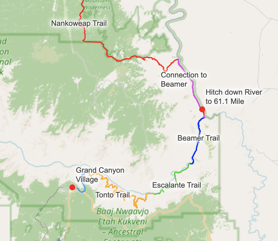
More details can be found on my Hayduke page.
Bright Angel to Tonto to South Bass to North Bass
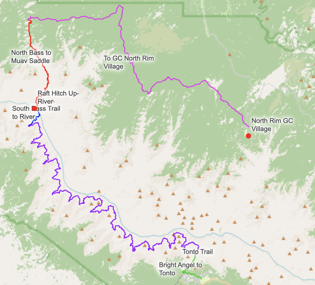
Another Option to go from the South Rim to the North Rim is by taking the Tonto Trail to the South Bass Trail. When you get to the river, you’ll need to hitch up-stream with a motorized raft. This again is best done in the morning. On the south bass trail. there is a ridge you can see rafts docked across on the other side of the river. You will need to shout across the river at them, and can likely organize transport up-river in the morning. Because you’ll need to go up river, only a motorized raft group can do it. But it’s a super quick hitch across from the TINY beach at the end of the south bass trail. I’d recommend sleeping on the beach near the Ross Wheeler Boat Wreck, and giving yourself about an hour+ to get over to the pickup point just east of Shinumo Creek, on the South Rim side of the river. Here’s a rough GPX track of the route with key hitch points marked.
North Bass trail is pretty slow going, as is getting down from the Tonto. The tonto is going to be very dry, so definitely get Water information from the rangers. Budget two to three days to get down to the Ross Wheeler Boat, and another full day to get up to Muav Saddle. It’s going to be another day (28 miles) to the North Rim of the GC.
Gear Notes
The AZT covers wildly different environments, so gear choices involve real trade-offs. A few things I learned:
- Pack: I brought the ULA Photon custom pack for this hike and found it genuinely frustrating — the side pockets are poor for water access and the hipbelt pockets require two hands to close. I’d go back to the Granite Gear Crown2 without hesitation. Don’t overthink the pack for a 30-day trip — use what you know works.
- Solar: I ran a solar panel setup on the AZT. It worked decently but I damaged the setup within the first 100 miles. The sun exposure in Arizona makes solar genuinely useful here. More on this can be found in my smartphone and battery setup post or solar post.
- Snowshoes: I brought snowshoes in 2023 due to the exceptional snow year. In a normal year, these are unnecessary. Check conditions before you go.
- Water capacity: Carry more than you think in the desert sections. The desert stretches south of Tucson and in the northern plateau can have long water carries. 4+ liters of capacity is reasonable.
My Packing List (2023)
Photographs
video from the trail