Hiking the Colorado Trail
The Colorado Trail might be the best thru-hike in the country for what you get per mile (although I do think the AZT is more spectacular). It’s 486 miles and takes about a month. The CT doesn’t require any permits, and runs through some pretty spectacular areas of the American West. I’ve done it twice-to-thrice-ish (three times if you count the CDT, and then another good chunk on my collegiate loop Nolan’s 14 hike.). Once in 2014 as my first-ever thru-hike, and again in 2020 during COVID. I plan to hike it again, because it’s JUST a great trail.
As a Colorado native, I have a lot of fond feelings toward this trail. It’s amazingly beautiful while also having some pretty tough hiking. The afternoon thunderstorms can be downright frightening, and there’s a ton of fourteeners you can bag as side trips if you’re up for those #SideQuests.
Colorado Trail Map
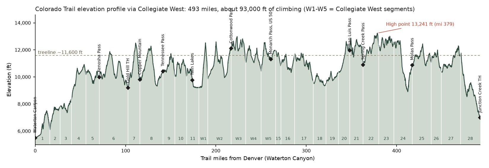
This is the trail route, via Collegiate West. You should definitely be doing Collegiate West unless there’s a compelling reason to do the Collegiate East Route. The map below shows the main segments, key resupply access points with their trail mile (SOBO going from “Denver”), and the elevation profile. Collegiate West is the default route here because it really is the better trail! It’s higher and a lot prettier than Collegiate East. Numbers may be slightly off of the “official route” in any given year, as some things change, and this was based off of my GPX track I recorded/have used for planning.
USGS topo with my track via Collegiate West (Collegiate East dashed). Tap a segment for its stats, drag along the elevation profile to move along the trail, or use Locate me to find your nearest trail mile. Open the map full screen ↗
| Colorado Trail at a glance | |
| Length | about 492 miles via Collegiate West; 485.8 via Collegiate East |
| Total climbing | about 93,000 ft Denver to Durango via Collegiate West |
| High point | 13,241 ft on segment 22 (Spring Creek Pass to Carson Saddle) |
| Miles above treeline (~11,600 ft) | about 129 |
| Segments | 28 plus five on Collegiate West, Waterton Canyon (southwest of Denver) to Junction Creek (Durango) |
| Permits | None |
Downloads: the Garmin course files further down on the page split the trail at resupply points, and the GPX splitter has a Colorado Trail preset if you want your own splits to add to your Garmin.
Colorado Trail thru-hike: what you should know before starting
The Colorado Trail runs from “Denver” to Durango. It doesn’t actually leave from Denver. It leaves from a trailhead in a suburb outside of Denver, which is genuinely a pretty shitty starting location. Most hikers go Southbound (westbound), which is the direction where the elevation gains are gentler, although you’ll be starting off in a burn area and pretty meh scenery. I personally recommend going Northbound (eastbound).
There are no permits required for the CT.
Season and Timing
The Colorado Trail runs at pretty high elevation. Most of the trail sits above 10,000 feet, with sections pushing past 13,000. Over 100 miles sit above treeline. Snow doesn’t clear at the high passes until mid-July in a heavy year, and comes back by mid-September. It’s good to remember that treeline is around 11,600 feet across the entire state, so you’ll want to be at or below that by the afternoon, when possible, to avoid thunder storms.
Best start window: July 1 to July 20. Starting this window gives you the best shot at dry passes through the Collegiates and San Juan ranges before fall storms arrive. I started my 2014 hike on July 12 and finished right before the monsoons turned ugly (although there were 3 days of straight rain that was absolutely miserable). My 2020 COVID hike started in August and I hit the first snow of the season, which was actually quite delightful!
The afternoon thunderstorm season in Colorado run from ~July through August. So you should plan to be off exposed ridgelines by around noon every day, and be prepared to rapidly drop in elevation if a thunderstorm rolls in.
When does the snow melt out?
“Start in early July” is the standard advice, which is pretty spot-on. I pulled the daily snowpack from the 25 NRCS SNOTEL stations within 15 km of the trail, all falling above 10,000 ft. I looked at annual data from 1992–2026, and found the day each station was effectively free of snow (less than 0.3 in of snow-water for five straight days).
The stations sit at 10,000–11,600 ft, and the trail is often higher than that, topping out above 13,000 feet. Most of the trail IS below treeline, though, so this is a pretty good measure of overall trail accessibility. Across stations in the same range and year, melt-out comes about 14 days later per 1,000 ft of elevation gain, so the last column extrapolates each range’s station dates up to the highest point the trail reaches there. North faces and cornices are going to have snow hanging on for longer, and south faces are going to melt out sooner.
| Range | Stations melt out: median and “very high” snow years | Trail high point | High point snow-free, roughly: median and “very high” snow years |
| Front Range and Tenmile (segments 5-8) | Jun 4 / Jun 17 | 12,514 ft | Jun 23 / Jul 6 |
| Sawatch and Collegiates (9-11, CW1-CW5, 15) | May 22 / Jun 3 | 12,990 ft | Jun 24 / Jul 5 |
| Cochetopa Hills (16-19) | May 5 / May 14 | 11,767 ft | May 18 / May 27 |
| San Juans (20-25) | May 24 / Jun 7 | 13,241 ft | Jun 23 / Jul 7 |
| La Platas (26-28) | May 18 / Jun 4 | 12,303 ft | Jun 12 / Jun 29 |
| Direction | Earliest start, typical year | Earliest start for 9 years in 10 | What sets it |
| Southbound from Denver | Jun 17 | Jun 29 | Front Range and Tenmile |
| Northbound from Durango | Jun 16 | Jul 1 | San Juans |
So pretty much you’re in good shape for a relatively snow-free trek if you start on the trail between July 1–20. Absolutely huge snow years can run well behind the numbers listed above for melting out. The San Juan stations melted out 28 days late in 1995 and 22 days late in 2019 (which would still have been fine for an early July start). 2026 was the earliest melted out year in the record
How Long Does A Thru-Hike Take?
A fit hiker doing 20-mile days can finish in 25 days pretty easily. I think it’s a solid 3 to 4-week thru-hike. Budgeting a 5th or 6th week can be nice if you really want to take your time. My 2014 hike took about a month including a couple of zeroes and short days. My 2020 COVID hike was about 3 weeks.
Days by pace
| Pace | Hiking days | With 3 zeros | Average climbing |
| 12 mi/day | 41 days | 44 days | 2,257 ft/day |
| 15 mi/day | 33 days | 36 days | 2,821 ft/day |
| 18 mi/day | 27 days | 30 days | 3,385 ft/day |
| 20 mi/day | 25 days | 28 days | 3,762 ft/day |
| 25 mi/day | 20 days | 23 days | 4,702 ft/day |
Most people land between 15 and 20 miles a day once they are acclimated. The first few days above 10,000 ft are slower for almost everyone coming from sea level. As a pro-tip, see if you can get a prescription for Acetazolamide (Diamox) from your doctor. This is the only proven drug to help with altitude sickness. If you take it 24 hours before exposure, you’ll likely do fine. Also will alleviate altitude sickness symptoms somewhat quickly, although you should come down from altitude to be effective. If you do take Diamox, you’ll definitely be peeing a lot, so make sure to consume more water.
Food carries between resupply points
| Stretch (Denver to Durango) | Distance | Days at 15 mi/day | Days at 20 mi/day |
| Waterton Canyon TH → Gold Hill TH (Breckenridge) | 103 mi | 6.9 | 5.1 |
| Gold Hill TH (Breckenridge) → Copper Mountain | 13 mi | 0.9 | 0.7 |
| Copper Mountain → Tennessee Pass (Leadville) | 25 mi | 1.7 | 1.3 |
| Tennessee Pass (Leadville) → Twin Lakes | 33 mi | 2.2 | 1.6 |
| Twin Lakes → Cottonwood Pass (Buena Vista) | 43 mi | 2.9 | 2.1 |
| Cottonwood Pass (Buena Vista) → Monarch Pass (Salida / Monarch Lodge) | 44 mi | 2.9 | 2.2 |
| Monarch Pass (Salida / Monarch Lodge) → San Luis Pass (Creede) | 87 mi | 5.8 | 4.4 |
| San Luis Pass (Creede) → Spring Creek Pass (Lake City) | 15 mi | 1.0 | 0.7 |
| Spring Creek Pass (Lake City) → Molas Pass (Silverton) | 54 mi | 3.6 | 2.7 |
| Molas Pass (Silverton) → Junction Creek TH (Durango) | 75 mi | 5.0 | 3.8 |
The longest food carry I listed is from Waterton Canyon TH to Gold Hill TH (Breckenridge) at 103 miles. For a 20-mile a day thru-hike, this is a 4-5 carry, which I feel is fine. If that sounds awful, you can hitch into Fairplay (or even walk into Jefferson) at mile 70 off of Kenosha Pass if you don’t think you can do 20 mile days from the outset. For my first thru-hike, I sent a resupply package to Jefferson and picked it up from the corner store, and that was fine too.
In the middle of the trail, Lake City from Spring Creek Pass is the default resupply; Creede is the other option, about 10 miles into town from the San Luis Pass trailhead (sometimes hitchable).
Navigation
The CT is well-signed and an amazingly, beautifully well-groomed trail. It makes it a terrific thru-hike for those that are new to long distance trails and learning to be better at navigating. You can do this one with some old-school maps and guidebooks (my first thru of it). However, FarOut (formerly Guthook) has a Colorado Trail guide that makes it stupid-easy to hike. I’d honestly just buy that at this point.
The official trail maps from the Colorado Trail Foundation are also great. In addition to FarOut, I tend to download topo maps before any hike I do, and primarily use Gaia for trail navigation. Cell service on the CT is often available at high points, and has been getting better every year.
Colorado Trail Segments
Below I list the mileage, ascents, and high points for each segment along the Colorado Trail. I promote that the default route is Collegiate West (Collegiate West, CW1–CW5). These values are computed from my GPS track, so may be slightly different from the official numbers in any given year. Gain and loss are traveling westbound/southbound from “Denver”-to-Durango. Segments 11 and 15 are split where Collegiate West leaves and rejoins them.
| Seg | From → to | Miles | Trail miles | Gain / loss (ft) | High point (ft) |
| 1 | Waterton Canyon TH → South Platte River TH | 16.3 | 0–16 | +2,884 / −2,257 | 7,505 |
| 2 | South Platte River TH → Little Scraggy TH | 11.3 | 16–28 | +2,582 / −866 | 7,841 |
| 3 | Little Scraggy TH → FS-560 (Rolling Creek) TH | 12.4 | 28–40 | +1,997 / −1,476 | 8,361 |
| 4 | FS-560 (Rolling Creek) TH → Long Gulch | 16.1 | 40–56 | +3,292 / −1,486 | 10,928 |
| 5 | Long Gulch → Kenosha Pass | 14.8 | 56–71 | +2,157 / −2,323 | 10,515 |
| 6 | Kenosha Pass → Gold Hill TH | 31.9 | 71–103 | +5,219 / −6,022 | 11,879 |
| 7 | Gold Hill TH → Copper Mountain | 13.2 | 103–116 | +3,802 / −3,195 | 12,514 |
| 8 | Copper Mountain → Tennessee Pass | 25.4 | 116–141 | +4,819 / −4,197 | 12,283 |
| 9 | Tennessee Pass → Timberline Lake TH | 13.3 | 141–155 | +2,502 / −2,880 | 11,719 |
| 10 | Timberline Lake TH → Mount Massive TH | 12.9 | 155–168 | +2,591 / −2,606 | 11,300 |
| 11 (part) | Mount Massive TH → Twin Lakes | 13.6 | 168–181 | +1,288 / −2,128 | 10,636 |
| CW1 (part) | Twin Lakes → Sheep Gulch | 9.9 | 181–191 | +3,547 / −2,912 | 12,530 |
| CW2 | Sheep Gulch → Cottonwood Pass | 25.9 | 191–217 | +6,221 / −3,962 | 12,602 |
| CW3 | Cottonwood Pass → Tincup Pass Road | 16.1 | 217–233 | +3,435 / −4,422 | 12,990 |
| CW4 | Tincup Pass Road → Boss Lake TH | 16.9 | 233–250 | +2,642 / −3,288 | 12,306 |
| CW5 | Boss Lake TH → Ridge above South Fooses Creek | 16.0 | 250–266 | +3,657 / −2,151 | 12,554 |
| 15 (part) | Ridge above South Fooses Creek → Marshall Pass | 6.0 | 266–272 | +399 / −1,447 | 11,932 |
| 16 | Marshall Pass → Sargents Mesa | 15.0 | 272–287 | +2,985 / −2,254 | 11,686 |
| 17 | Sargents Mesa → Colorado Hwy 114 | 21.0 | 287–308 | +2,931 / −4,941 | 11,767 |
| 18 | Colorado Hwy 114 → Saguache Park Road | 14.0 | 308–322 | +1,473 / −1,558 | 10,262 |
| 19 | Saguache Park Road → Eddiesville TH | 13.8 | 322–336 | +2,117 / −1,315 | 10,420 |
| 20 | Eddiesville TH → San Luis Pass | 12.5 | 336–348 | +3,080 / −1,451 | 12,628 |
| 21 | San Luis Pass → Spring Creek Pass | 14.8 | 348–363 | +3,147 / −4,200 | 12,877 |
| 22 | Spring Creek Pass → Carson Saddle | 17.4 | 363–380 | +3,747 / −2,293 | 13,241 |
| 23 | Carson Saddle → Rio Grande Reservoir Road | 16.5 | 380–397 | +3,669 / −3,418 | 13,015 |
| 24 | Rio Grande Reservoir Road → Molas Pass | 20.5 | 397–417 | +4,077 / −5,793 | 12,697 |
| 25 | Molas Pass → Bolam Pass Road | 20.9 | 417–438 | +3,680 / −3,473 | 12,448 |
| 26 | Bolam Pass Road → Hotel Draw Road | 11.3 | 438–450 | +1,908 / −2,586 | 11,998 |
| 27 | Hotel Draw Road → Kennebec TH | 21.1 | 450–471 | +3,950 / −2,722 | 12,303 |
| 28 | Kennebec TH → Junction Creek TH | 21.9 | 471–492 | +2,830 / −7,469 | 11,770 |
Collegiate East (the alternate)
Collegiate East is the other way from Twin Lakes to Monarch Crest and is 78 miles compared to 85 miles on Collegiate West. Collegiate East is also about 1,600 ft less elevation gain (although that’s practically nothing). It is also a lot less scenic having only about 2 miles above treeline compared to 39 miles above treeline on Collegiate West. The main reason to do Collegiate East is for access to some 14ers (if you wanna bag a bunch for some reason), and because it puts you right past Mt. Princeton Hot Springs which can be very nice for [an expensive] zero.
| Seg | From → to | Miles | Gain / loss (ft) | High point (ft) |
| 11 (part) | Twin Lakes → Clear Creek Road TH | 7.7 | +1,375 / −1,689 | 9,930 |
| 12 | Clear Creek Road TH → Silver Creek TH | 17.8 | +4,747 / −4,243 | 11,850 |
| 13 | Silver Creek TH → Chalk Creek TH | 23.3 | +4,562 / −5,578 | 11,903 |
| 14 | Chalk Creek TH → US Hwy 50 | 20.6 | +4,000 / −3,573 | 10,171 |
| 15 (part) | US Hwy 50 → Ridge above South Fooses Creek | 8.7 | +3,177 / −107 | 11,926 |
The steepest segments by climbing per mile (southbound): 7 (288 ft/mi), CW2 (253 ft/mi), 20 (246 ft/mi). Segment 28 into Durango drops 7,469 ft — northbounders start the trail with that climb.
Planning the Hike
Resupply
The CT is straightforward to resupply on without mailing any boxes. Unless you’re vegan or have specific dietary needs, you can make it work with grocery stores and gas stations along the way. The trail towns are all pretty decent! My 2020 COVID hike used four resupply points (all mail drops) to minimize in-person contact: Copper Mountain at mile 119 (friends brought supplies), a contactless mail drop near Twin Lakes at mile 175, Monarch Mountain Lodge at mile 249, and Molas Lake at mile 409. In a normal year you’d stop in more towns and have a more varied experience. I personally love the towns of Salida and Leadville, so would definitely recommend swinging into those. Besides, you can buy a Melanzana outside of the quota/reservation system if you’re thru-hiking the CT (or CDT!) and hitch into leadville!
| Town | Approx. Mile | Access | Notes |
| Waterton Canyon TH | 0 | On trail | Drive or take a Lyft to the trailhead. |
| Breckenridge | 100 | Short hitch (also a bus) | Full service ski town, great resupply. Backcountry Brewing + excellent gear shops. |
| Copper Mountain | 122 | On trail | Resort with restaurants — can do pretty decent resupply out of Copper. It’s effectively on trail. |
| Twin Lakes | 167 | On trail | Small store. You’ll want to send a mail drop to the store, or hitch into Leadville from here. |
| Mt. Princeton (on Collegiate East) / Buena Vista (Collegiate West) | 212 / 215 on CW via cottonwood pass | Hitch | Buena Vista is a full resupply town. Mt. Princeton Hot Springs is a great option for a zero if you wanna spend some cash. You can also send resupply boxes to Mt. Princeton. |
| Salida / Butterfly House | 248 (258.4 on collegiate west) | Hitch | Full service town, good restaurant scene, easy hitch from the highway, and super friendly to hikers. Overall good hostel in town. On Collegiate West, you will also be at Monarch Pass at 258.4, and can resupply there (gas station style), or send a resupply package to the Butterfly House (hostel). |
| Monarch Mountain Lodge | ~260 | On trail | Lodge with restaurant. They accept resupply packages (used them in 2020). |
| Creede | ~348 | San Luis Pass TH, then ~10 mi walk or hitch to town | Small but trail-friendly town. From the San Luis Pass trailhead it is about 10 miles into town — sometimes hitchable, otherwise plan to walk it. |
| Lake City (or Creede) | ~363 | Hitch from Spring Creek Pass | Great trail town, full service, excellent resupply. The default resupply for the middle of the trail: hitch from Spring Creek Pass (Hwy 149). |
| Silverton | 425 | Hitch | Charming old mining town, full resupply |
| Durango | 486 | On trail | Southern terminus — full service city, fly home from here, or rent a car or take a bus to Denver. |
Miles are approximate. The Colorado Trail Foundation maps are more precise.
Why I Navigate With a Garmin Watch
A Garmin Fenix is the best navigation upgrade I’ve made to my backpacking kit. It does four things my phone can’t.
- It sips power. The battery is tiny, so a typical power bank tops it up 15-20 times. In my experience it runs about 4 whole days of solid navigation between charges.
- Built-in flashlight. The Fenix 7X (and some other Fenix models) has an LED flashlight. It’s one of the features I use most on trail.
- More time in nature. The course lives on my wrist, so my phone stays in my pocket.
- Off-course alerts. It pings you when you drift roughly 150 feet off the course. It has saved me MANY miles of unnecessary backtracking.
Garmin Fenix 7X Solar Sapphire on Amazon Read my Garmin watch review
Affiliate link: if you buy through it I may earn a small commission at no extra cost to you.
Garmin Courses: Colorado Trail Resupply Splits
5 Garmin courses (471 miles, via Collegiate West), one per resupply leg. Download the ZIP, import the TCX files into Garmin Connect, and send them to your watch.
Each file is one stretch between resupply stops from my plan, with the start and end loaded as named course points. I split them up because Garmin Connect and the Garmin watches often crash with long courses or a lot of waypoints. Runs Waterton Canyon (Denver) to Durango. Leg 3 follows Collegiate West and ends at Monarch Pass (US 50, the hitch to Salida and Monarch Mountain Lodge), and Molas Lake sits right by Molas Pass.
Heads up: I hiked the Colorado Trail before I owned a Garmin watch, so I never ran these on trail. They’re built from my resupply plan, not from a course I carried. The tracks come from third-party sources, so accuracy isn’t guaranteed. Carry backup navigation, and check the course against your own maps. If a long leg won’t import, split it smaller with the Trail GPX Converter.
The San Juans
The western half of the trail through the San Juan Mountains is the most difficult but also the most spectacular section of trail. Although, I also have a real love of the Collegiate Peaks. In the San Juans, you’ll be doing long (and frightening, there WILL be lightening) traverses above treeline and crossing passes at 13,000+ feet, and dealing with the most exposed terrain on the trail.
In 2014 I bagged four Colorado Trail fourteeners as side trips off the main trail in the collegiate range: Massive, Shavano, Tabeguache, and St. Louis Peak (Collegiates into the San Juans). These are all reasonable additions if you are up for it!
If fourteeners are a primary goal, the Collegiate Loop is worth a serious look. It’s a ~167-mile loop through the Collegiate Peaks area that swings by multiple fourteeners and links up nicely with the CT.
Colorado Trail Tips for New Thru-Hikers
The Colorado Trail is one of the most popular thru-hike options for people doing their first long trail.
- Don’t mail too many resupply boxes. The CT has excellent resupply options across the entire trail. Unless you have very specific dietary needs, you don’t need to send yourself food packages. The trail towns are good. Shipping boxes ties you to post office hours and kills flexibility. If you want to skip a town or move your schedule, you’re stuck waiting for a package. Trust the grocery stores and gas station options as much as possible.
- Start with enough time. The trail is harder than many other long distance trails. Make sure you plan to have extra time, which will allow you to take a few zeroes to recover from potential injury, or explore some side quests.
- Afternoon thunderstorms . Every single day during monsoon season (July-August) these things are likely to roll in. Try to get off exposed ridgelines before noon, and check the clouds around you before heading up above tree line for a long stretch in the afternoon. People get struck by lightning in Colorado yearly — and it can be pretty petrifying.
- The San Juans will humble you. The western half of the trail through the San Juans is the hardest section. It’s spectacular, but long traverses at 13,000 feet in unpredictable weather can be stressful.
- Town hitches are part of the experience. Most CT resupplies require hitchhiking. This is normal, safe, and usually easy in Colorado’s outdoor-friendly towns. If you’ve never hitchhiked before, the CT is a great place to learn!
Hitchhiking the Colorado Trail
Hitchhiking is a core part of the Colorado Trail experience!
Is Hitchhiking Safe on the Colorado Trail?
Yes, with normal common sense. The CT passes through rural Colorado mountain towns and resort corridors. The people giving you rides are often outdoor enthusiasts, ranchers, and locals who’ve seen thru-hikers before. I’ve hitchhiked hundreds of miles in Colorado and have never had a bad experience (I am a white dude though, so I understand this can be more concerning for others. Can be great with a travel buddy. You can also avoid hitchhiking with some well-planned resupply boxes).
How to Hitchhike Effectively
- Stand at a visible pull-off. Drivers need somewhere safe to stop. Don’t stand on a blind curve or at the top of a hill. Find a spot where cars can see you coming and have room to pull over.
- Look approachable. A smiling face and visible hiking gear gets you much further than looking like you’re homeless. Hold your poles, look approachable, make eye contact, smile, and wave at each car as it approaches.
- A sign may help. “Hiker to [Town]” on a piece of notebook paper likely increases success rates. Drivers know immediately where you’re going and whether they can help.
- Know your hitchhike points before you get there. The CT hits major highways at predictable spots. Salida (Hwy 50), Buena Vista (Hwy 24), and Twin Lakes (Hwy 82) are easy hitches. More remote spots like Spring Creek Pass (Lake City) require patience.
CT Hitchhike Difficulty by Section
| Hitch | Difficulty | Notes |
| Breckenridge (Hwy 9) | Easy | Ski resort town, lots of outdoor traffic, tons of pickups. Usually <15 min. |
| Twin Lakes to Leadville (Hwy 82) | Easy | Busy weekend traffic toward Aspen and Leadville. Weekday mornings can be slower. |
| Buena Vista (Hwy 24) | Easy | BV is a very hiker-friendly town. High traffic volume on this road. |
| Salida (Hwy 50) | Easy | There’s a big parking lot, where you can usually talk with folks and secure a ride into town. |
| Spring Creek Pass to Lake City (Hwy 149) | Harder | Remote highway, lower traffic. Patience required. |
| San Luis Pass TH to Creede | Hard | About 10 miles into town on a remote road. Sometimes hitchable; be ready to walk. |
| Silverton (Hwy 550) | Moderate | Reasonable traffic. |
Getting to and from Trail
Eastern Terminus (Waterton Canyon, near Denver)
The eastern terminus is at Waterton Canyon, about 25 miles southwest of Denver. You should Lyft, or arrange a shuttle to the trailhead. The canyon itself is a wide dirt road for the first 6+ miles. And then it moves into a burn area that has long-ish water carries, and isn’t very scenic.
Western Terminus (Durango)
Durango is served by the Durango-La Plata County Airport with direct flights to Denver, Dallas, Phoenix, and a few other hubs. It’s a full-service city with good restaurants and a great celebration meal waiting at the end. Fly or drive back from here.
Gear Notes
- Rain and wind protection: The afternoon thunderstorms in Colorado are frequent, and will typically occur every afternoon during the main hiking season. You’ll definitely be hiking in rain at least some of the time, so will want a rain jacket that’s reliable. I use OutDry jackets, because they that literally cannot wet out. Standard DWR rain jackets fail in sustained downpours, which can happen in Colorado. Typically by the early evening hours, the storms have passed and you can dry out your gear (although there may be days-on-end with rain in some years).
- Insulation: A down puffy jacket, or a alpha direct fleece + wind jacket should be enough in the summer.
- Shoes: This trail is well groomed, so isn’t too bad on footwear. I use Hoka Challengers — very padded, light, flexible, and one pair is fine for the entire trail.
- Trekking poles: Highly recommended. It takes weight off of your body, so why not use them?!
2014 Gear List (first thru-hike)
2020 Gear List (COVID year, solar panel setup)
Trail Updates from the Trail
Below are the journal posts and emails I sent during both Colorado Trail hikes. The 2014 posts are from my first thru-hike. The 2020 posts document the COVID-era hike with very different logistics.