Introducing a PCT trail guide for your Garmin. It shows elevation profiles, waypoints that are coming up, and notifies you when you’re off the trail. It has both the topo map integration, as well as a simple “breadcrumb trail” to follow. You can even record your tracks so you don’t lose out on the strava kudos. It’s like having the power of FarOut, but from your watch!
Get the beta on your watch in about two minutes.
Download the file for your model, copy it to the watch with a USB cable, done.
Beta 0.4-beta (2026-10-14). I built it for my fenix 7X and it’s the only watch I’ve run it on. It installs on 100+ other Garmins, but those are untested. If you experience problems, let me know and I’ll push some updates.
GPS tracking is enabled by default, but you can improve battery life. That is what keeps your mile and the off-trail warning real-time, and in the default GPS-only satellite mode it costs about what a normal hiking activity does. But if you want it to use less battery (it’s the PCT, after all, you probably know when you’re on the trail!), you can change that! On the watch, hold UP → GPS and move it from Continuous to Every 5 min (one check every five minutes) or On demand (one fix when you open the app or ask for one). Leave Satellites on GPS only unless you are in a canyon or heavy trees and need better coverage.
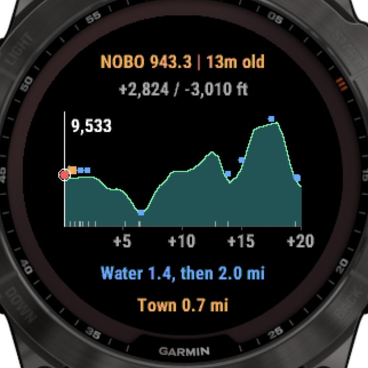
The lower-refresh modes show how old your fix is (“943.3 | 12m old”), so a stale mile never looks live. And if you wander off the trail the app switches GPS to live by itself until you are back.
While you are recording a hike the watch is using GPS to draw your track anyway. As far as I know the app just reads those same fixes and does not add a second GPS draw, so these settings matter mostly when you are not recording.
What it shows
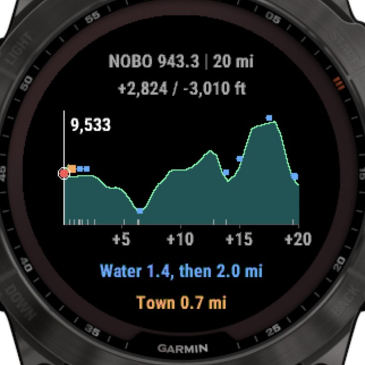
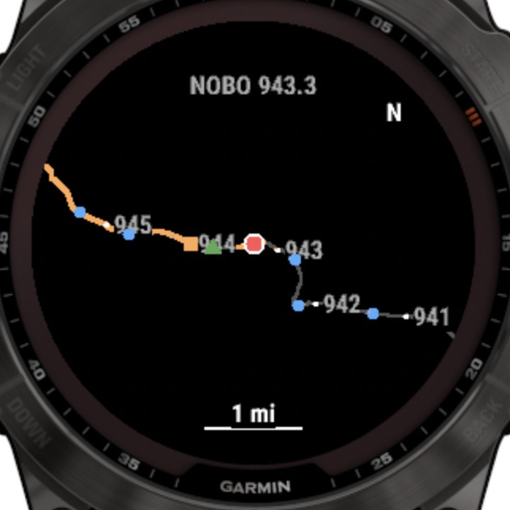
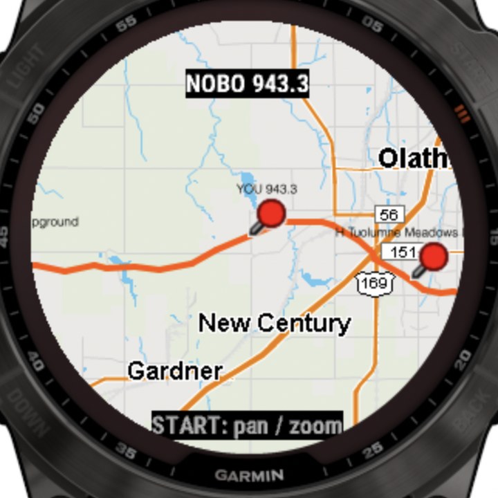
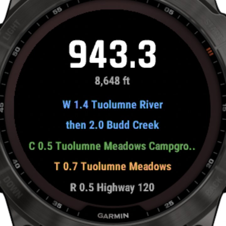
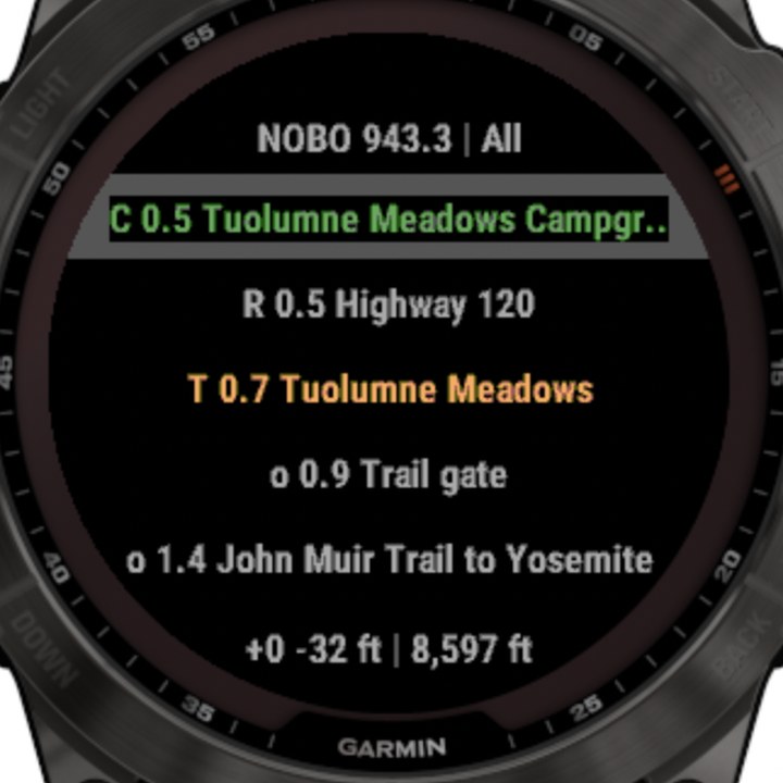
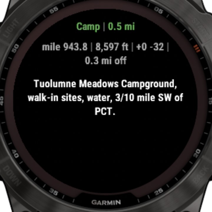
Screenshots are from the Garmin simulator running the fenix 7X build.
How to use it
1. Open it
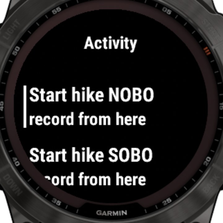
From the watch face press START and pick PCT Guide from the activity list. (It also lives in your glance list: press UP from the watch face. The glance shows your mile, or a live REC clock if you are recording.)
2. Let it find you
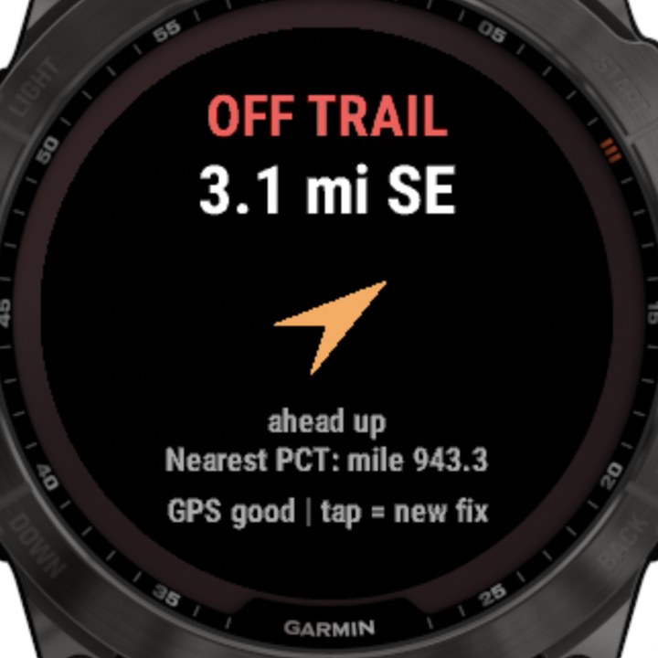
It tracks you live while the app is open: your mile updates as you move, and it buzzes if you step off the trail. (Satellite mode defaults to GPS-only, the cheap one.) To stretch the battery, switch GPS to Every 5 min or On demand in settings; then the screen tells you how old the last fix is (12m old) so a stale mile never looks live.
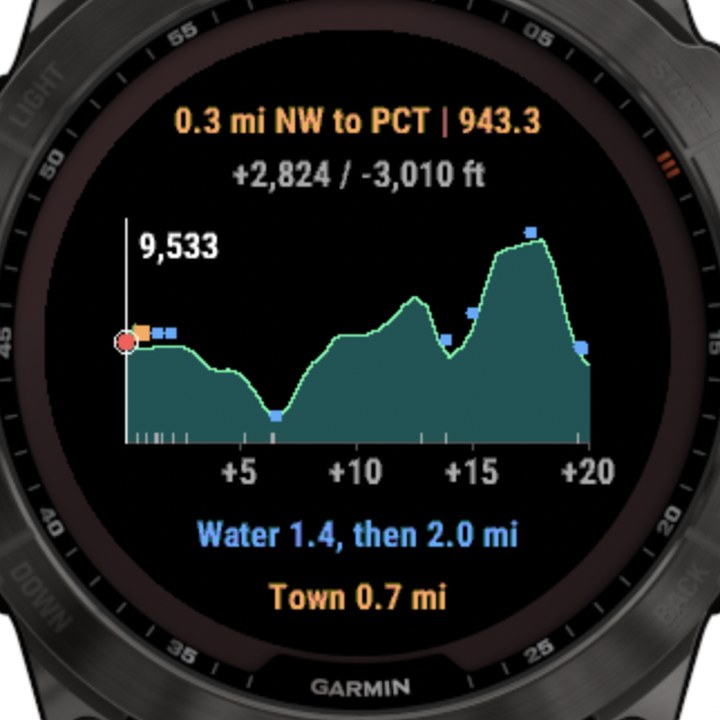
No fix yet? It says Searching GPS. Not on the trail? The header turns amber with how far and which way to the PCT (“820 ft NW to PCT”). Farther than about a mile it takes over the screen with a big OFF TRAIL, the distance, and an arrow. In the low-power modes, GPS switches to live updates by itself while you are off the trail, then drops back once you are within about 80 m.
3. Move around
| Do this | Get this |
|---|---|
| Swipe left / right (or DOWN / UP) | Profile → Map → Topo → Now → List |
| Tap right / left half of the screen (profile, map, Topo) | Zoom in / out |
| START on the Topo page | Pan and zoom Garmin’s map. BACK to leave. |
| On the List page, scroll then START | Open that waypoint’s full note |
| Hold UP (or long-press the screen) | Settings menu |
4. Record your hike
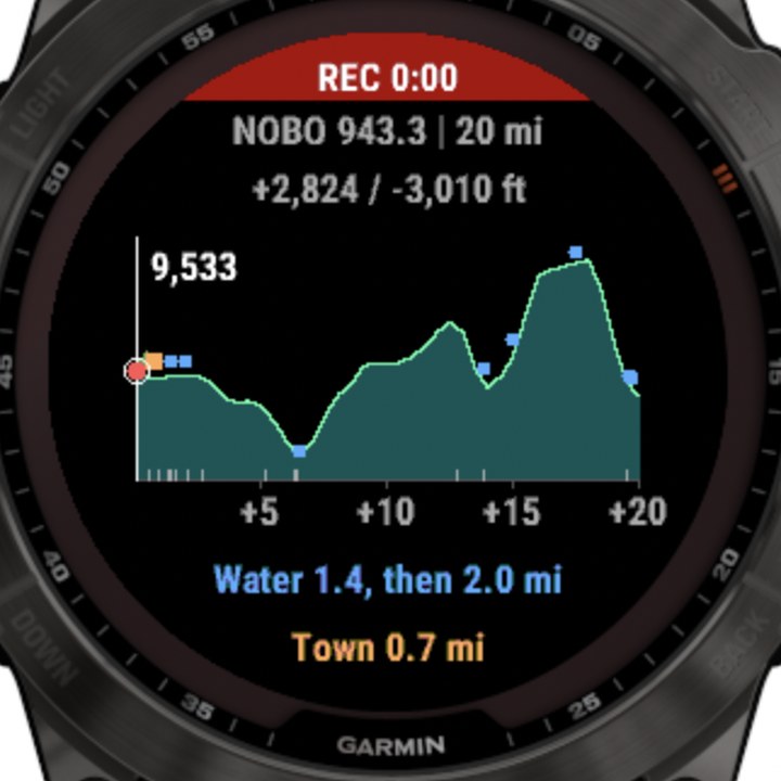
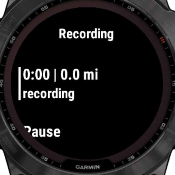
Press START and choose Start hike NOBO or SOBO. A red REC band shows across the top of every screen with your moving time. It is a normal Garmin hiking activity: it saves to your watch history and syncs to Garmin Connect.
5. Leaving the app
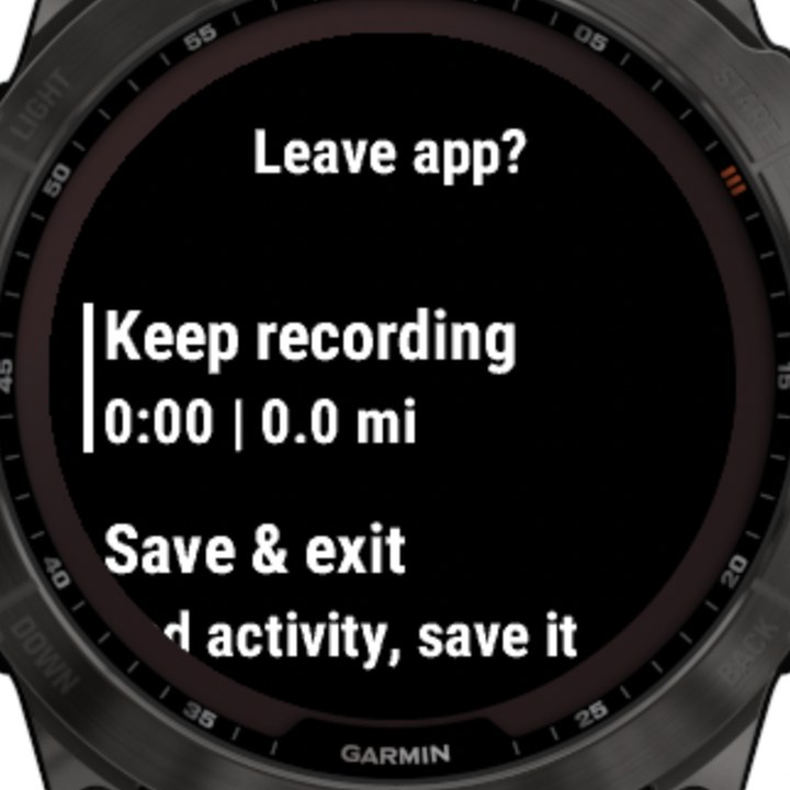
While recording, BACK never just exits. It asks Keep recording / Save & exit / Discard & exit. If the watch ever closes the app on you, the recording is saved and the next launch tells you what happened.
6. Browse any mile (no hiking required)
Hold UP → Jump to mile… has 40 landmarks from Campo to Manning Park. Then UP/DOWN scrub by 0.1, 1, 10 or 50 miles. BACK returns to GPS. Good for planning at the kitchen table, or testing on a watch that is not on the PCT.
7. Battery settings
| Setting | Options |
|---|---|
| GPS | Continuous (default) · Every 5 min · On demand · Off |
| Satellites | GPS only (default, lowest power) · Multi-GNSS · Multi-band L1+L5 (best under trees, costs more) · Auto (SatIQ) |
| Off-trail buzz | Vibrates when a fix is more than 150 m from the PCT |
Continuous GPS in GPS-only mode costs about what a normal hiking activity does. The app does almost no work between fixes: it ignores movement under ~20 m and only redraws when something changed.
Install it on your watch
This is a “sideload”: you copy one file onto the watch. It is not in Garmin’s app store. It takes about two minutes and nothing you do here can brick the watch. You need a USB cable that carries data (not a charge-only one).
- Download the file for your model from the form below. It is called
PCTGuide-<model>.prgand it is about 1.4 MB. - Plug the watch into your computer and wake it.
- Copy the file into the
GARMIN/Appsfolder on the watch (steps for your computer are below). - Eject / unplug. The watch picks up the new app after you disconnect. It will show as PCT Guide in the activity list.
Windows
- Quit Garmin Express if it opens (right-click its tray icon → Exit). It can grab the watch first and hide it.
- Plug in the watch. Open File Explorer → This PC. Your watch shows up as a device (for example fenix 7X), not as a lettered drive.
- Double-click it → Internal Storage (sometimes just the watch name) → GARMIN → Apps.
- Drag
PCTGuide-...prgfrom your Downloads folder intoApps. If asked about replacing a file, say yes: that is the update. - Click the Safely Remove Hardware icon (or just unplug). Watch the watch: it takes a few seconds to load the app.
Older watches mount as a drive letter (like GARMIN (E:)). Same thing: GARMIN\Apps.
Mac
Macs cannot open most Garmin watches in Finder (they talk MTP, a protocol macOS skips). Install OpenMTP, a free helper app. Garmin Express cannot do this job.
Download OpenMTP for Mac (free, about 125 MB):
Not sure which? Apple menu → About This Mac. “Chip: Apple M-something” = Apple Silicon. “Processor: Intel” = Intel. Open the downloaded file and drag OpenMTP to Applications. First launch: right-click → Open if macOS balks. Official site: openmtp.ganeshrvel.com · newest version.
- Quit Garmin Express, Google Drive, Dropbox and OneDrive. They love to grab the watch and OpenMTP will say “device busy or not connected.”
- Plug in the watch, wake it, open OpenMTP and click the refresh button above the right-hand pane. You should see your watch’s storage.
- In the right pane, open GARMIN → Apps.
- In the left pane find the downloaded
PCTGuide-...prg(Downloads), then drag it into the right pane’sAppsfolder. - Eject the watch (unplug it). Give it a few seconds to load.
If the watch appears as a normal GARMIN volume in Finder, skip OpenMTP: drop the file into GARMIN/Apps and eject.
Linux or Chromebook
- Plug in the watch and wake it. Most file managers (GNOME Files, Dolphin, the Chromebook Files app) show it automatically as a device.
- Open it → Internal Storage → GARMIN → Apps.
- Copy
PCTGuide-...prgin, then eject the watch.
If the watch does not appear on Linux, install mtp-tools / gvfs-mtp and reconnect.
Can I install it from my phone (Bluetooth, Android, iPhone)?
- Bluetooth: no. Garmin watches only take apps from a phone through the Connect IQ Store. This beta is not in the Store, so there is nothing for the phone app to install.
- iPhone / iPad: no. iOS cannot copy files onto a Garmin watch over USB either.
- Android: sometimes, but I do not recommend it. A few phones can do it with a USB-C (OTG) cable and a file manager that speaks MTP (for example X-plore). I have not tested that, so use a computer if you can.
Easiest path from a phone: use the “Email this page to myself” button at the top, then finish on a computer.
It did not work / troubleshooting
- Watch does not show up. Different cable, different port, unlock the watch. Make sure Garmin Express is closed.
- No
Appsfolder. Make one named exactlyAppsinsideGARMIN. Capital A. - App is not in the list after unplugging. Restart the watch (hold the light button, Power off, then on). Check you used the file for your model.
- Which file is mine? On the watch: Settings → System → About. Pick the closest name in the list. Models that share a build are grouped on one line.
- Update or remove. Replace the file with the new build to update. To remove, delete
PCTGuide-...prgfromGARMIN/Apps.
Try the beta
Pick your watch, leave an email, download. That is it. The email is so I can tell you when there is a fixed build and ask what broke.
The fine print
- It is a beta, and it is not a safety device. Carry a paper map or a phone you trust. Water sources change; the notes are not a water report.
- The notes are from 2020 and there are no crowd reports. If a note says a creek flows, that was one hiker, in one year.
- GPS in a canyon or under heavy trees wanders. The default GPS-only mode is the battery saver; multi-band is better in bad terrain.
- Tested on one watch. Other models compile and are untested.
Data and credits. Trail line and official mile markers: Pacific Crest Trail Association data. Water, camps, road crossings, towns and trail notes: Halfmile’s PCT data, © Halfmile Media (2020 edition). This beta is a personal project and is not affiliated with or endorsed by Garmin, the PCTA, or Halfmile.
Your email. It is stored on this site, used for beta news and bug questions, never sold or shared. Ask and I delete it.